|
Morocco:
West Atlas Bicycle Africa / Ibike Tours |
|||
 |
Atlantic Coast: South to Azzemour, El Jadida, Oualidia, Safi | ||


 |
|||
| At its best the coastal road south of Casablanca looks out over farmland, which drops away into the sea. | |||


 |
|||
| Increasing, cows and crops are giving way to long skinny housing and apartment developments. Some of these are only about 100 meters wide and run the length from the road to the ocean. It is ironic that as the land is transformed from a relatively nature state to a built environment the marketers attached names to the development like Paradise, Azure, Blanca, Corniche, Golden, Eden, Pearl, Dreamland, Promanade, Savannah, Scheherazade, Sunset, and Sea Moon (whatever that is), as in Residence Azur, Blue Lagon, Golden Beach, and Ola Blanca. It is only going to get more dreary as many more strips of development are starting construction. | |||
  Along with housing come other modern oddities like cell
towers disguised as palm trees -- they are often the only "palm trees" in the
area. The housing is also traffic generators, so the under designed road is not
always pleasant to bicycle along. Along with housing come other modern oddities like cell
towers disguised as palm trees -- they are often the only "palm trees" in the
area. The housing is also traffic generators, so the under designed road is not
always pleasant to bicycle along.Also noteworthy are the number of pipeniere, plant nurseries, along the road. The new developments don't have a lot of outdoor landscaping associated with them, but it may be that the residents are avid planter box and indoor gardeners. |
|||
 |
Someplace between 30 km and 40 km (18-14 miles) southwest of Casablanca, the current wave of suburb and exurb development peters out and the landscape is more bucolic and there are more interest details to think about and ponder: There are row crops, some with drip irrigation. The roadside livestock includes cows, sheep, donkeys and horses. While most of the farms look like small-holders, there must be some bigger farms growing grains in the area to account for the combine on the road. The plastic tunnels (below) say, "horticulture and specialty crops". The fruit and produce salesmen, camp out in the shade of roadside trees, look more like they are hosting a social event than involved in an entrepreneurial activity. And between the farms and coast for much of this section are natural coastal dunes. |
 |
|
|
|


 |
 |
|
 |
 What
is interesting and pleasant is detracted from by the relative narrowness of the
road, abrupt edge to the asphalt, large vehicles, unyielding drivers and
occasional curvy sections of road. You can't just admire the scenery but also must stay
hyper alert to the road and traffic condition. What
is interesting and pleasant is detracted from by the relative narrowness of the
road, abrupt edge to the asphalt, large vehicles, unyielding drivers and
occasional curvy sections of road. You can't just admire the scenery but also must stay
hyper alert to the road and traffic condition.Donkey carts (right) are forced to the edges as well. |
 |
|
  The rural tranquility takes a break for the almost as tranquil town of Azzemour. The rural tranquility takes a break for the almost as tranquil town of Azzemour.At Azemmour, the Oum er-Rbia river meets the ocean. The river is one of Morocco's most important and reliable water carriers, beginning in the Middle Atlas Mountains (see references in West Atlas) at the source with the same name, 300 km due east, but the river is 555km long. |
|||
 |
Although
Azemmour's houses and streets may not fully meet the standards of a tourist
destination, the line of houses along the river is among the most picturesque
anywhere in the country. Azemmour is a quaint town, mostly off the main road, with a living medina in better condition than many other old cities in Morocco. There are some sights around that warrant a visit; the Kasbah Sidi Mehamad Benabdelah (a fortified residence) even if much of it is in ruins, the old powder house, and the Mellah (the former Jewish quarters), of which a synagogue is still infrequently in use. Azemmour has one of the nicest, traditionally red, city walls in the country, with small but well-kept gates. But as soon as you enter, the color red disappears, and white, blue and yellow start to dominate. |

|
|
 |


 |
 |
|
| About 10km south of Azzemour is el Jadida. | |||
 |


 |
 |
|
| El Jadida's most prominent historical and cultural site is the Fortress of Mazagan established by the Portuguese in the early 16th century. The Portuguese legacy of the citadel are the wall, Portuguese crest above the gates, and the Bastion St. Antione with cannons. | |||
 |


 Portuguese towns of this era often included churches, mosques and synagogues. Such is the case for el Jadida. The late gothic Church of Assumption most recently was used as a theater. The mosques, with its unique five-sided minaret, which is a converted Portuguese lighthouse, is still in active us. The abandon synagogues, who facade looms high above the surrounding building, is a converted from a Portuguese court house. It can be identified by the Star of David (six-pointed star) just below the top of the eves. An inverted crescent, constructed of the same material and in the same style, is above the star. After the 18th century, the citadel served as a Mellah, Jewish quarter. |
 |
|


 |
 |
||
 El
Jadida breakwater protects it small fishing boat fleet and small port. At
present, the city's main exports are beans, almonds, maize, chickpeas, wool,
hides, wax and eggs. It imports cotton, sugar, tea and rice. El
Jadida breakwater protects it small fishing boat fleet and small port. At
present, the city's main exports are beans, almonds, maize, chickpeas, wool,
hides, wax and eggs. It imports cotton, sugar, tea and rice. |
|||


 |
|||
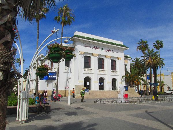
| Outside of the old town wall some the architecture that gets noticed are the Post Office, Municipal Theater, and a Private Chateau. A walk down main street is also a way to get the pulse of the town. | |||
 |


 |
 |
|
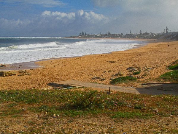
| The road south of el Jadida stay near sea level, which provide picturesque scenes of sandy and rocky beaches, fisherman wading in the water, the surfs endless sweep of the shore, and fishing boats pulled up on the dune, and the occasional cow that is oblivious to it all.. | |||

 Rarely
do road side vendor arrange such artistic display of there produce, but there
seems to be a competition among vendors in this area. The display to the left
had radishes, beats, a couple different kinds of lettuce and cabbage, fennel,
cilantro, and scallions, at least. Rarely
do road side vendor arrange such artistic display of there produce, but there
seems to be a competition among vendors in this area. The display to the left
had radishes, beats, a couple different kinds of lettuce and cabbage, fennel,
cilantro, and scallions, at least.The nearby vegetable garden (right( was almost as diverse, but add artichoke. |
|||
 |
 The
scenic delights of the coast are interrupted for several kilometers by the
Jorf Lasfar Port and Industrial area. The port is considered the second most
important port in Morocco. The complex includes: a power
plant, an oil refinery, desalinization plant, artificial fertilizer and
petrochemical factories, and facilities for exportation of phosphate and various
chemicals such as pure sulphur, ammonia, and sulphuric acid. The
scenic delights of the coast are interrupted for several kilometers by the
Jorf Lasfar Port and Industrial area. The port is considered the second most
important port in Morocco. The complex includes: a power
plant, an oil refinery, desalinization plant, artificial fertilizer and
petrochemical factories, and facilities for exportation of phosphate and various
chemicals such as pure sulphur, ammonia, and sulphuric acid. |
 |
|
 |


 |
 |
|
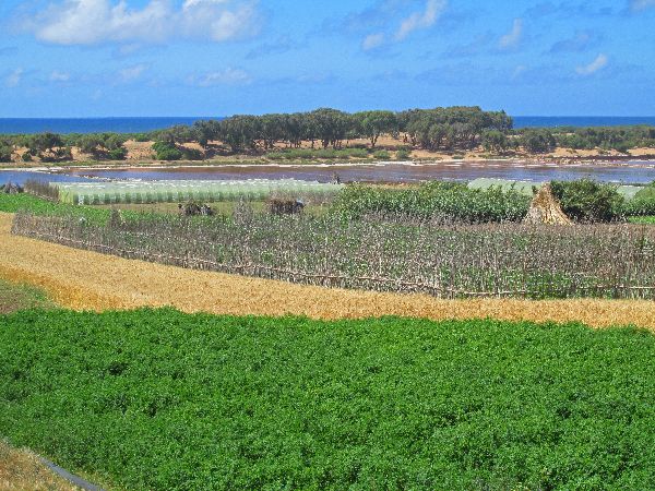
  South
of Jorf Lasfar the road is generally a little higher above the ocean and a bit
further inland, and regains a higher esthetic quality. A lot of the scenery is
different configurations of agriculture, lagoons, and dunes (above). There was
also some processing of sea salt (right) South
of Jorf Lasfar the road is generally a little higher above the ocean and a bit
further inland, and regains a higher esthetic quality. A lot of the scenery is
different configurations of agriculture, lagoons, and dunes (above). There was
also some processing of sea salt (right) |
|||
 |


 |
 |
|
  Oualidia
is primarily a vacation town adjacent to the ocean and a tidal lagoon. At least
mid-week, in the off-season, it is a quiet pleasant village, but it is clearly
ready for larger crowds than we saw. Oualidia
is primarily a vacation town adjacent to the ocean and a tidal lagoon. At least
mid-week, in the off-season, it is a quiet pleasant village, but it is clearly
ready for larger crowds than we saw.The specialty of Oualidia is oysters -- it is the "Oyster Capital of Morocco". Fresh, raw oysters on the half shell can be bought from street-carts. |
|||
 |
  Technology
notables for Oualidia are wind powered street lights. Each stanchion is
self-contained with a wind turbine, battery and array of LED lights. Technology
notables for Oualidia are wind powered street lights. Each stanchion is
self-contained with a wind turbine, battery and array of LED lights.To the right, almost blending with the street trees, the tallest "palm tree" is not a palm tree. |
||


 |
|||
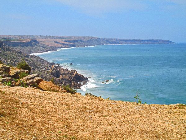
| From Oualidia to Cape Beddouza, the road pretty much stick to a high, flat bluff, along the coast. For much of the way you are gazing over a patch-work of farm land that extend almost to the sea. | |||

 Rather
desolate Cape Beddouza, is 35km south of Oualidia and 35km north of Safi. It is
here that the coastline changes from a southwest-northeast
direction, to a more north-south orientation. The shore also changes from having
some sandy beach, to the surf pounding up against the base of a cliff. Rather
desolate Cape Beddouza, is 35km south of Oualidia and 35km north of Safi. It is
here that the coastline changes from a southwest-northeast
direction, to a more north-south orientation. The shore also changes from having
some sandy beach, to the surf pounding up against the base of a cliff. |
|||


 |
 |
||
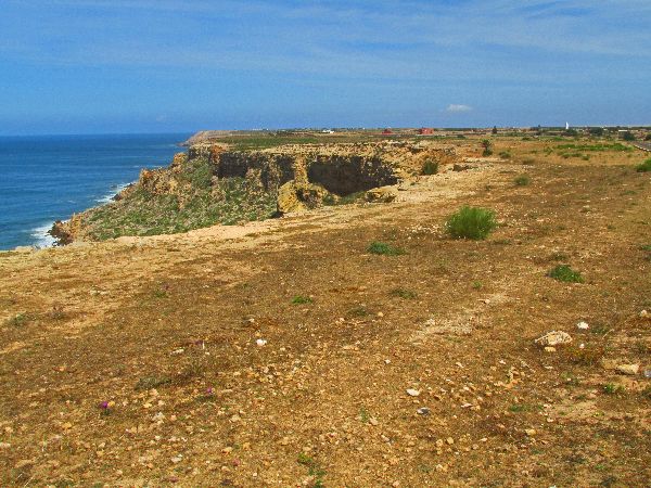
| The views are big and long, and coastline takes a turn for the rugged between Cape Beddouza and Safi. At Safi, the cliffs wither away, and the town sits on the shoreline. | |||
 |
One
of the first signs of Safi is the ships on anchor off shore. While the economic
engine for Safi is its port and industry, its cultural and historical treasures are in the
heart of the city. Safi is another town that dates its oldest existent infrastructure back centuries. According to historian Mohammed al-Kanuni, Safi must be identified with the ancient Thymiaterion or Carcunticus and was founded by the Carthaginian Hanno during his Periplus as related by Pliny the Elder. |
||
 |


 |
 |
|
 From 1488 to 1541, Safi was a protectorate of the Portuguese Empire. 1523, the Portuguese built Dar el-Bahar (Castle by the Sea), a fort and prison. One source has it built by Vasco da Gama's brother-in-law. |
|||
 |
 The
Kechla is another massive Portuguese-built fortress with
ramps, garden courtyards and gunnery platforms. It is at the top end of the
Medina, about 500m from the coast. (It was used as a prison until 1990). The
Kechla is another massive Portuguese-built fortress with
ramps, garden courtyards and gunnery platforms. It is at the top end of the
Medina, about 500m from the coast. (It was used as a prison until 1990).
In 1541, frustrated with the Wattasids’ policy of peaceful co-existence with the Portuguese, the Saadis, under the command of Muhammad al-Mahdi, overran southern Portuguese towns of Morocco, including Safi. |
 |
|


 |
|||
|
The Grand Mosque is the oldest mosque in Safi. It was constructed by the Mohades in the 12th-13th
century on the site of an earlier sanctuary. The mosque was particularly
important during the Merinids (14th C). Its very imposing minaret was
built during this period. The mosque was destroyed during the Portuguese era and rebuilt by the Alaouites. Safi's population is now predominately Moslem Berber and Arab, but at one time it was 20% Jewish. |
|||
 |


 |
 |
|
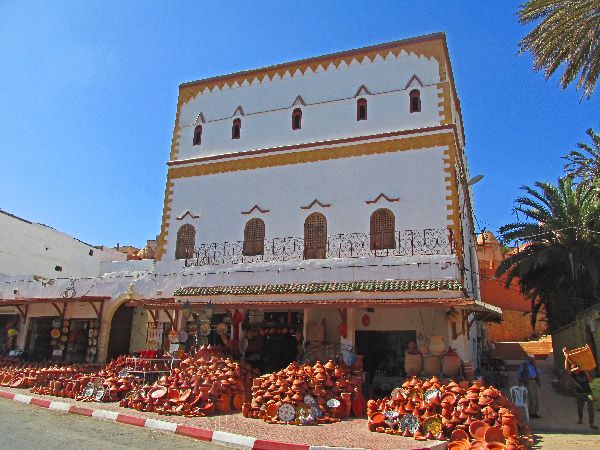
| Safi is known as the ceramic capital of Morocco. Large inventories of pottery can be found in several markets in and out of the Medina. | |||
 |
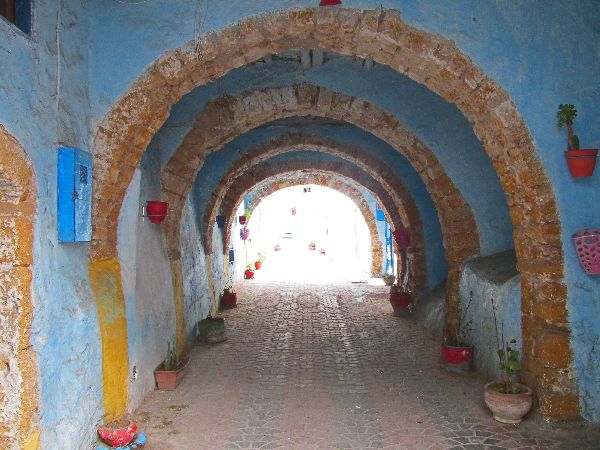  Safi Madina and souk
might be compared to Marakech. While it has some similar characteristics, more
importantly, it is smaller, calmer, quieter, friendlier, and generally more
welcome. One local residents said as much in saying, "we are not like Marakech."
Even the cats are more laidback. Safi Madina and souk
might be compared to Marakech. While it has some similar characteristics, more
importantly, it is smaller, calmer, quieter, friendlier, and generally more
welcome. One local residents said as much in saying, "we are not like Marakech."
Even the cats are more laidback. |
 |
|


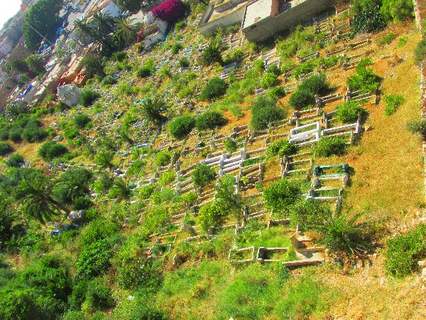 The domed buildings are
Islamic mausoleum usually for renowned Sufi marabouts (teachers). A Moslem
cemetery just outside the Medina wall.
The domed buildings are
Islamic mausoleum usually for renowned Sufi marabouts (teachers). A Moslem
cemetery just outside the Medina wall. |
|||


 |
|||
| Outside of the Medina there is clean town with a variety of accent colors. A few of these are Jacaranda street trees that bloom thick with purple flowers, a larger than life tagine sculpture, and a six story high mural of a boy and a girl with a top. | |||
 |
Safi has long been an important port: When Marrakech was the capital, Safi was
often its main port. In 1765, there is a record ofDutch,
Danish, British and French foreign trading houses. But in 1769, Sultan Mohammed
Ben Abdellah forced international trade to pass through Essaouira.
1942, World War II, Safi was one of the landing sites for American troops in “Operation Torch”, the initiative to recapture North Africa. Now, to the north of Safi center is the port and to the south is an industrial area. Safi is the main fishing port for the country's sardine industry, and also exports phosphates, textiles and ceramics. |
 |
|
 |
|||
|
|
Unique Programs To Special Places For Memories Of A Lifetime!
"Hosted by
DreamHost - earth friendly web hosting"
|
|

