|
Morocco:
Moyen Atlas Mountains Bicycle Africa / Ibike Tours |
|||
 |
Crossing Moyen Atlas to Boulemane | ||
| Topography from Er Rich to Sefrou. This most dramatic section is crossing the Moyen (Middle) Atlas. Even there the maximum slope riches less than 4%. | |||
 [Depending upon the quality of the underlying data graphs maybe only general representations of the topography.] |
|||
  Higher
in this region of the Haute Atlas, where moisture is more seasonal, agriculture is replaced by
grazing -- mostly sheep. Higher
in this region of the Haute Atlas, where moisture is more seasonal, agriculture is replaced by
grazing -- mostly sheep.The highway crosses the Haute Atlas at Col Tizi N'Talghaumt (pass) (elev. 1907m, ~5870 ft). A water hole has been built for livestock. The only trees in the area are planted. The hilltop seems to be above the treeline. |
|||
 It
is worth documenting! With views at every corner, the road gradually gives
up its elevation as it traverses hillsides and winds down valleys for miles. It
is worth documenting! With views at every corner, the road gradually gives
up its elevation as it traverses hillsides and winds down valleys for miles.
At every pull-out, there were bottles of honey set out (lower right), presumably for sale. Sellers were never visible. Unless there is a standard price per bottle that is common knowledge, it is difficult to figure out how a sale was made. |
|||


 |
|||
   The
next treat was snow-dusted peaks in the Atlas Range. When the weather is
delightfully warm and dry, it is hard to image a full blown winter. The
next treat was snow-dusted peaks in the Atlas Range. When the weather is
delightfully warm and dry, it is hard to image a full blown winter. |
|||


 |
 |
||
 |
Where most of the towns on the east side of the Atlas are built largely on flat
lands, Midelt is built on a hill. The photos above cover about 270o
of views from the top of a building at the center of town. It is also a new city so it lacks the defined neighborhoods and souks of traditional Moroccan towns. What is gained is wide boulevards with water features in the traffic circle. |
 |
|
 From the prominent apple sculpture in a traffic circle, it is logical to conclude that Midelt known for its apples. It was probably the time of year, but in the market there were more orange in the market than apples. Other produce of the district includes; walnuts, apricots, plums, pomegranates, wheat, corn, and a wide variety of garden vegetables. |
 |
||
  Again,
timing is everything, but we happened on the bread delivery hour. One vendor was
delivery low, round loaves, and another delivery van was filled with long,
skinny, French baguettes. Again,
timing is everything, but we happened on the bread delivery hour. One vendor was
delivery low, round loaves, and another delivery van was filled with long,
skinny, French baguettes. |
|||
 |
 On
the subject of food, we had a very memorable couscous dinner at a small
restaurant in Midelt. The elements were served separately so each diner could
assemble their own plate. The ingredients were served as a bowl of cooked
couscous grain, a platter of assorted vegetable and a platter of meat. Each
component was superbly prepared. On
the subject of food, we had a very memorable couscous dinner at a small
restaurant in Midelt. The elements were served separately so each diner could
assemble their own plate. The ingredients were served as a bowl of cooked
couscous grain, a platter of assorted vegetable and a platter of meat. Each
component was superbly prepared. |
 |
|

|
A
short walk from Midelt, past Kasba Outhmane Ou Moussa, is
Kasbah Myriem, the home of Monastere Notre Dame de l'Atlas. The monastery is built around the two
surviving members of 1996 Tibhirine assassination*. The Tibhirine Priory was
inaugurated in 1938, near Médéa, Algeria. After the terrorist attack, the
surviving monks moved to a monastery annex in Fez. In 2000, they moved to
a complex outside Midelt, that they now share with the Franciscan
Missionary Sisters. The monks and nuns
cultivate the modest agricultural land of the
monastery, support the small village school, offer welcomes to guests and
pilgrims, and run a weaving and embroidery workshop/training program. * On the night of 26–27 March 1996, seven monks from the Atlas Abbey of Tibhirine, near Médéa, in Algeria, belonging to the Roman Catholic Order of Cistercians of the Strict Observance (known as Trappists) were kidnapped during the Algerian Civil War. They were held for two months, and were found dead in late May 1996. |
 |
|
  At
some point of another most visitors to the neighbor visit the weaving workshop and
showroom (left). The workshop trains about thirty young local girls and
is led by a religious sister. At
some point of another most visitors to the neighbor visit the weaving workshop and
showroom (left). The workshop trains about thirty young local girls and
is led by a religious sister. |
 |
||
 |
 Between
the Haute Atlas range and the Moyen Atlas range is a long, broad, flat valley.
It must be the inspiration for many a Moroccan "country ballad" with its
dramatic, sometimes snow-capped mountains, nomadic, tent-dwelling shepherds and
frontier, Berber autonomy campaigners leaving their marks and defining the
culture. Between
the Haute Atlas range and the Moyen Atlas range is a long, broad, flat valley.
It must be the inspiration for many a Moroccan "country ballad" with its
dramatic, sometimes snow-capped mountains, nomadic, tent-dwelling shepherds and
frontier, Berber autonomy campaigners leaving their marks and defining the
culture. |
 |
|
 |
From the early 20th century minerals were exploited around Zaida. The most
abundant of these was lead. The major mines have closed but the piles of mine
tailing remain. It is not the place you want to be in a dust storm: The tailings
have been tested and were found to contain lead (Pb), zinc (Zn), copper (Cu),
cadmium (Cd), chromium (Cr) and nickel (Ni). On the bright side, there is
no arsenic. In Zaida, there is a "Pizza Hut" (right). The signs are there, but
the don't sell any pizza. It is a visual disconnect. It might have sold pizzas
in the past, or maybe it is preparing to sell pizzas in the future, but right
now it sells tajine. |
 |
|
  Next,
on the list of interesting signs -- timing is everything -- is the "Barriere de
Neige" (Snow barrier). Besides being no snow in the vicinity, presently, over
the next 40 km the road climbs only 200 meters -- it is very flat. After that,
the road climbs 220m in 15 km to a pass that is likely closed by heavy winter
snow. Next,
on the list of interesting signs -- timing is everything -- is the "Barriere de
Neige" (Snow barrier). Besides being no snow in the vicinity, presently, over
the next 40 km the road climbs only 200 meters -- it is very flat. After that,
the road climbs 220m in 15 km to a pass that is likely closed by heavy winter
snow.Here are some views of the 40 km of flat, from Boulaajoul to near Enjil. |
|||
 |


 |
 |
|
  While
riding across terrain with little topography can be easy, very relaxing and impressive
with space, hills may be harder but they offer details that tend to be more
stimulating and vibrant. While
riding across terrain with little topography can be easy, very relaxing and impressive
with space, hills may be harder but they offer details that tend to be more
stimulating and vibrant. |
|||
 |


 |
 |
|
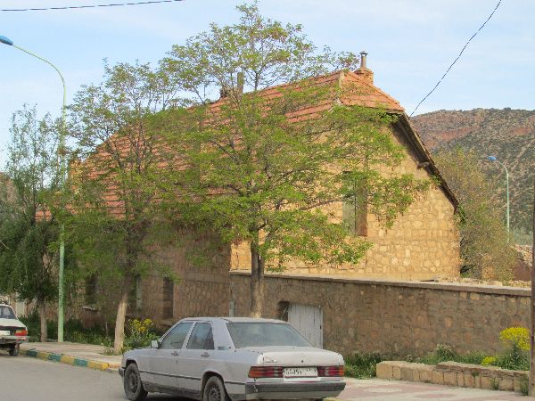  Just
on to the western slope is the mountain village of Boulemane. The stone
masonry buildings and red tile roofs speak to the French presence in the history
of the small town. The areas history is also reflected in the former church,
which has been transformed into a mosque (right). Just
on to the western slope is the mountain village of Boulemane. The stone
masonry buildings and red tile roofs speak to the French presence in the history
of the small town. The areas history is also reflected in the former church,
which has been transformed into a mosque (right).The town's beautiful location, quaint character, and hammam (Turkish bath) should be a draw for visitors, but there is no hotel in Boulemane (the closest hotel is more than 70km, 45 miles, away) so most sightseers will have to make it there as a day trip. |
|||
 |


 |
 |
|
| The route out of the Middle Atlas, through the Fès-Boulemane Region, is very picturesque: | |||
 |


 |
 |
|
| Jagged rocks, forests, high plains, prosperous looking farms, winding mountain roads, large valleys, | |||
 |


 |
 |
|
 |
  and
variations on these themes. and
variations on these themes. |
 |
|
 |
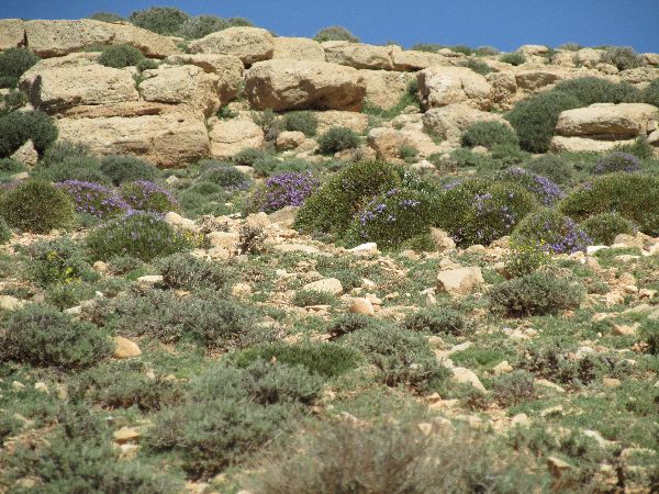
 The corridor is relatively sparsely populated.
The land status fluctuates from forest to rangeland with wildflowers, to
agriculture. The agriculture varies from sheep and cattle herding, to fruit
orchards, grains, and field crops, to greenhouse horticulture. The corridor is relatively sparsely populated.
The land status fluctuates from forest to rangeland with wildflowers, to
agriculture. The agriculture varies from sheep and cattle herding, to fruit
orchards, grains, and field crops, to greenhouse horticulture.The crop that was being harvested at the time was potatoes, which were being stored, at least temporarily, in rows, under long orange tarps. |
 |
|
 |


 |
 |
|
 |
|||
|
|
Unique Programs To Special Places For Memories Of A Lifetime!
"Hosted by
DreamHost - earth friendly web hosting"
|
|