|
Morocco:
Amazigh Bicycle Africa / Ibike Tours |
|||
 |
East of the Atlas: Amazigh | ||
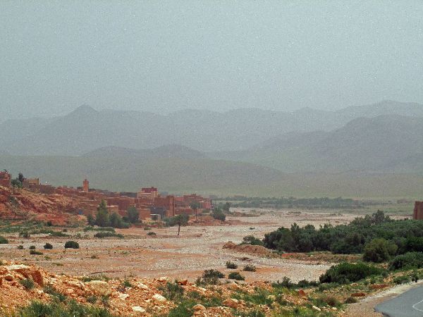
| Boumalne Dades to Errachidia is about 190km. Despite the appearance of the compressed graph below, the maximum slopes is 2.5%. | |||
 [Depending upon the quality of the underlying data graphs maybe only general representations of the topography.] |
|||


 |
|||
| Out of Boumalne Dades, there is a short climb to get to the top of the ridge and then it is 130 kilometers of mostly gentle decent to Goulmima. | |||


 |
|||
| The net drop is 600 meters. If you do the math it is a downgrade of less than one-half of one percent -- on a bike, it is real sweet with a tailwind. While the road is basically flat, this is a front row seat for the Haute Atlas. They tower above the plains, anything but flat. | |||


 |
|||
| The next oasis and town is Tinghir. The green belt is the plains of the Todra River. The vistas around town are lovely. The public spaces are friendly. | |||


 |
 |
||
| It is a small town, but large enough for a daily market and a good variety of shops. And connected enough with the rest of the world to have modern digital communications. | |||


 |
|||
| Intriguing was a narrow alley where every door was a hairdresser. Bike shops are always a welcome sight. And you can get a good meal. | |||


 |
|||
 The
section of town that was the Mellah, Jewish Quarter, is now the women's market.
In this same section of town are some women's weaving cooperatives. Most welcome
visitors and have showrooms. We were told that the hand prints above the door
(far right) were vestiges of the Jewish Community, but we could find no other
signs of the centuries of residency here. The
section of town that was the Mellah, Jewish Quarter, is now the women's market.
In this same section of town are some women's weaving cooperatives. Most welcome
visitors and have showrooms. We were told that the hand prints above the door
(far right) were vestiges of the Jewish Community, but we could find no other
signs of the centuries of residency here. |
|||


 |
|||
 |
The segment between
Tinghir and Tinejdad is less than sixty kilometers. As has been the pattern,
outside of towns the population is sparse but there are still a variety of looks
to the landscape; new tree varieties, power transmission lines, beehives and
Bedouin tents to name a few. One disturbing find was a kilometer long section dense with plastic garbage (left). It was miles from the nearest town and no garbage dump was in sight. Generally, the Moroccan countryside is still relatively light with garbage, but this valley seemed to be the Moroccan garbage vortex. There was no obvious explanation why so much garbage piled up here. |
||


 |
|||
 Bilingual
(Arabic and Tamazight) and trilingual sign (Arabic, French, and Tamazight) like
this one at a school (left) in Tinejdad, are seen with some regularity in the
towns on the eastern slope of the Atlas, especially at schools, but also some
other government buildings. The are the result of an initiative to preserve the
Berber culture. At one extreme in this Moroccan culture war are those that want
forced Arabization of Morocco. (i.e. A 1996 decree bans the use of Berber names
in registering newborn children, mandating all must be given Arabic names.) This
is countered by organizations promoting diversity, social justice, and human
rights, like the Amazigh Cultural Associations. They were successful in getting
the teaching of Tamazight language in primary school, starting in 2004. Bilingual
(Arabic and Tamazight) and trilingual sign (Arabic, French, and Tamazight) like
this one at a school (left) in Tinejdad, are seen with some regularity in the
towns on the eastern slope of the Atlas, especially at schools, but also some
other government buildings. The are the result of an initiative to preserve the
Berber culture. At one extreme in this Moroccan culture war are those that want
forced Arabization of Morocco. (i.e. A 1996 decree bans the use of Berber names
in registering newborn children, mandating all must be given Arabic names.) This
is countered by organizations promoting diversity, social justice, and human
rights, like the Amazigh Cultural Associations. They were successful in getting
the teaching of Tamazight language in primary school, starting in 2004.
|

|
||
| The Berbers themselves argue, that they are a separate race of people, completely different from the Arabs, who have oppressed them ever since they arrived in the 7th century. [Increasingly, educated, urban Berbers refuse to even use the term "Berber", referring to it as a pejorative word, derived from barbarian, imposed by foreign imperialists. Instead, they refer to themselves as Imazighen, “free men” in the Berber language (Amazigh being the singular).] | |||


 |
 |
||
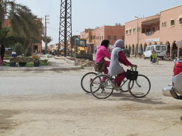
 A
prominent characteristic of Tinejdad is the number of bicyclists, both
male and female. Until a better candidate is found, it should be considered the
"Bicycle
Capital of Morocco". A
prominent characteristic of Tinejdad is the number of bicyclists, both
male and female. Until a better candidate is found, it should be considered the
"Bicycle
Capital of Morocco". |
 |
||


 |
 |
||
  We
return to the savannah for the relatively short ride (25km) between Tinejdad and
Goulmima. We
return to the savannah for the relatively short ride (25km) between Tinejdad and
Goulmima. |
|||
   Goulmima
is both an old and new city on the steppes. The new section of town is along the
highway, is laid out in a grid pattern and is home to the hamburger, shwarma and
pizza restaurants, and most other commercial activity in town. The old town is
set on a low hill more in the middle of the palmerie. Goulmima
is both an old and new city on the steppes. The new section of town is along the
highway, is laid out in a grid pattern and is home to the hamburger, shwarma and
pizza restaurants, and most other commercial activity in town. The old town is
set on a low hill more in the middle of the palmerie. |
 |
||


 |
|||
 Goulmima
old city is a warren of winding streets, over the road buildings, complex
lighting and unfamiliar compositions ranging from laden donkeys filling the
narrow alleys to rooftops dotted with satellite antennas. Like many Moroccan old
towns, it also not considered a desirable address by many these days, in part because upkeep is
time-consuming and if one falls short a rain storm can transform a building into
ruins. Goulmima
old city is a warren of winding streets, over the road buildings, complex
lighting and unfamiliar compositions ranging from laden donkeys filling the
narrow alleys to rooftops dotted with satellite antennas. Like many Moroccan old
towns, it also not considered a desirable address by many these days, in part because upkeep is
time-consuming and if one falls short a rain storm can transform a building into
ruins. |
 |
||


 |
 |
||
   The
traditional dress for Berber women is this region is a wrap with embroidery at
the waist (left) The embroidery can change from town-to-town and dark seems to
be most common for the wrap, but there is some variation. The
traditional dress for Berber women is this region is a wrap with embroidery at
the waist (left) The embroidery can change from town-to-town and dark seems to
be most common for the wrap, but there is some variation.In the old town, we were invited to have tea with a family (right). Lack of a common language limited the exchange, but our hosts were pleased to offer the hospitality and we appreciated the chance to sit and get a glimpse inside of a house. |
 |
||
  Like
most of the towns in the Berber region, Goulmima had a Mellah, Jewish Quarter.
The building (left) with two doors was identified as the former synagogue. One
door was the entrance for women and the other for men. Other than that subtle
architecture there is nothing that indicates it Jewish roots. Like
most of the towns in the Berber region, Goulmima had a Mellah, Jewish Quarter.
The building (left) with two doors was identified as the former synagogue. One
door was the entrance for women and the other for men. Other than that subtle
architecture there is nothing that indicates it Jewish roots. |
|||


 |
 |
||
 Flipping
again from urban to rural for the trip from Goulmima to Errachida (60km).
There is little to say about the topography, but there are a few points of
interest. Flipping
again from urban to rural for the trip from Goulmima to Errachida (60km).
There is little to say about the topography, but there are a few points of
interest. An interesting geological formation is a sedimentary sandstone wall that looks like a brick wall (left). Also on the route, set behind a high fence, is the International Foundation for Ecological Research, Errachida Center
(right), which evidently it has some connection to the Ministry of Environment, Qatar. |
|||
 Later you reach the Reserve Biologique D'Aferdou for the Restoration of Wildlife (left).
|
|||
  A
mystery of the section was a very yellow crop that was growing out nearer the
mountains on several farms. It wasn't seen -- or at least noticed -- before Goulmima or after Errachidia, and it was never close enough to the road to
identify. A
mystery of the section was a very yellow crop that was growing out nearer the
mountains on several farms. It wasn't seen -- or at least noticed -- before Goulmima or after Errachidia, and it was never close enough to the road to
identify.Retail is rare in these parts, so when a café presented itself on the road side about two-thirds of the way it seems reasonable to stop. There were a few other customers passing the time, but it was indeterminate where they might have come from.
Three kilometers further is the verdant gorge of Kser Tarda. Perhaps some residents from them make their way to roadside café to pass the time. There were a couple other bare bones developments (right) along the highway into Errachidia. |
 |
||
  There
is so little signage that a simple sign becomes the subject of a photo. There
is so little signage that a simple sign becomes the subject of a photo.A caution sign (left) is presumably alerting drivers that there is a slight curve in the highway. A lane designation sign (right) shows that bicycle are expected to use the shoulder of the
road. |
|||
  Errachidia's every appearance is that of a modern and friendly town. The main
roads are wide and clean and the town is known for its active evening street
life. A lot of red clay is used in the modern residential architecture so it has
some of the appearances of Marrakech. Errachidia's former name, Ksar es Souk, suggest that it has some history as a market town on the former
caravan routes that ran through the region but there is little evidence physical
evidence of this. Errachidia's every appearance is that of a modern and friendly town. The main
roads are wide and clean and the town is known for its active evening street
life. A lot of red clay is used in the modern residential architecture so it has
some of the appearances of Marrakech. Errachidia's former name, Ksar es Souk, suggest that it has some history as a market town on the former
caravan routes that ran through the region but there is little evidence physical
evidence of this. The French reinvigorated the town when they choose to use it
as a garrison town for the Foreign Legion, and as an administrative center. The
Kingdom of Morocco maintains a significant military presences here, which is an
integral part of the modern economy of the city. The town was renamed
after independence for the first Alaouite leader, 17th-century sultan Moulay
Rachid. It has reemerged as a major commercial center for the region and has major
market days three times a week (Sunday, Tuesday, and Thursday). The French reinvigorated the town when they choose to use it
as a garrison town for the Foreign Legion, and as an administrative center. The
Kingdom of Morocco maintains a significant military presences here, which is an
integral part of the modern economy of the city. The town was renamed
after independence for the first Alaouite leader, 17th-century sultan Moulay
Rachid. It has reemerged as a major commercial center for the region and has major
market days three times a week (Sunday, Tuesday, and Thursday). |
|||


 |
|||
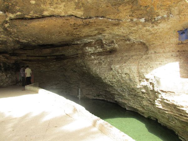
 If you pass through the oasis villages of Mediouna, Assrir, and Bni Hheli, you will get to best side trip out of Errachida is to
Source Bleue de Meski. If you pass through the oasis villages of Mediouna, Assrir, and Bni Hheli, you will get to best side trip out of Errachida is to
Source Bleue de Meski.
Source Bleue de Meski is a spring at the village of Meski that is set in a palm grove. It was first developed by the French Foreign Legion. The spring emerges at the bottom of the cliff and flows out into a large man-made pool. It is now the swimming hole for local kids and a stop for tour buses. |
|||

  |
 |
||
 |
|||
|
|
Unique Programs To Special Places For Memories Of A Lifetime!
"Hosted by
DreamHost - earth friendly web hosting"
|
|


