| |
   Namibia
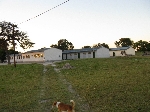
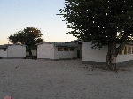
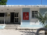
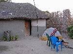
schools are on break during May so we didn't have any opportunity to visit a
classroom, but there is a school (left) and clinic (right) in Linyanti so we
took a morning stroll with Emil, a student, to look at the buildings and peek in the windows.
The school has a computer lab. Namibia
schools are on break during May so we didn't have any opportunity to visit a
classroom, but there is a school (left) and clinic (right) in Linyanti so we
took a morning stroll with Emil, a student, to look at the buildings and peek in the windows.
The school has a computer lab.
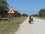   The
road is paved most of the way to Linyanti. Beyond it is soil, but
generally a very smooth and high quality surface, similar to hard, smooth
composition used in rural America called soil cement. These roads
may not be formulated exactly the same way, but through using the right
clay, wetting, smoothing and packing the road during construction, they seem
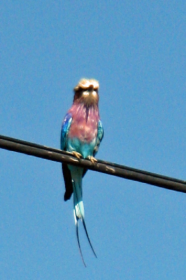
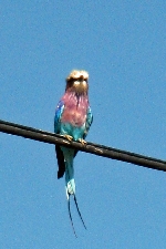
to achieve the same results. [The picture of the Lilac Breasted Roller has
absolutely nothing to do with road construction, but they are beautiful
birds and they aren't usually easy to photograph. It is also interesting to
ponder where they perched before man built telephone and power lines across
Africa.] The
road is paved most of the way to Linyanti. Beyond it is soil, but
generally a very smooth and high quality surface, similar to hard, smooth
composition used in rural America called soil cement. These roads
may not be formulated exactly the same way, but through using the right
clay, wetting, smoothing and packing the road during construction, they seem
to achieve the same results. [The picture of the Lilac Breasted Roller has
absolutely nothing to do with road construction, but they are beautiful
birds and they aren't usually easy to photograph. It is also interesting to
ponder where they perched before man built telephone and power lines across
Africa.]
  Our
destination for the day was Sangwali. In addition to what was
becoming a pattern of afternoon socializing, we also made the rounds of the
"town." Similar to Linyanti, Sangwali was more of an area than a
center. At one end, on the outskirts, was the police station, down the
road from that was the tribal court (per custom, in the course of the
afternoon we formally presented ourselves to the Headman of the town and the
Chief of Our
destination for the day was Sangwali. In addition to what was
becoming a pattern of afternoon socializing, we also made the rounds of the
"town." Similar to Linyanti, Sangwali was more of an area than a
center. At one end, on the outskirts, was the police station, down the
road from that was the tribal court (per custom, in the course of the
afternoon we formally presented ourselves to the Headman of the town and the
Chief of
 Police), further on a few stores were scattered
with several hundred meters between
them, next came a sign-less church, and another walk brought you to the
offices of
the local administration. Beyond that the main road split. One
road lead to the schools and clinic on the opposite outskirts of "town". The other road led to the site
of the future Sheshe Crafts Center, the Sangwali Museum (4 km) and Mamili National
Park (12 km). (The Sheshe Crafts Center used to have a building but now it has been
relegated to a closet in the administration building.) Along the
way people were
carrying things and working at various activities. Police), further on a few stores were scattered
with several hundred meters between
them, next came a sign-less church, and another walk brought you to the
offices of
the local administration. Beyond that the main road split. One
road lead to the schools and clinic on the opposite outskirts of "town". The other road led to the site
of the future Sheshe Crafts Center, the Sangwali Museum (4 km) and Mamili National
Park (12 km). (The Sheshe Crafts Center used to have a building but now it has been
relegated to a closet in the administration building.) Along the
way people were
carrying things and working at various activities.
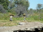
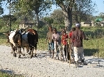
  As we walk around people
did various kinds of work; carrying thatch, pounding sorghum off the stock,
hitching a ride on a sled as the ox team hauled it home, collecting fire wood
and water, fixing a motor, etc.
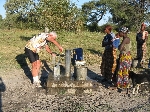
While access to universal electric power is
still a ways off here (maybe only a few months), there was access to safe drinking water throughout the
town and it seemed that everyone had a cell phone. You could see the
tower with the cell antennas from almost every place in town. As we walk around people
did various kinds of work; carrying thatch, pounding sorghum off the stock,
hitching a ride on a sled as the ox team hauled it home, collecting fire wood
and water, fixing a motor, etc.
While access to universal electric power is
still a ways off here (maybe only a few months), there was access to safe drinking water throughout the
town and it seemed that everyone had a cell phone. You could see the
tower with the cell antennas from almost every place in town.
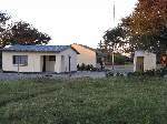
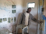
 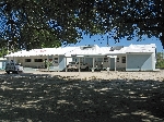 The
health clinic is a clean and well maintained building. We arrived
during the siesta so it was very quite. One member of our group went
in to have an abrasion dressed (incurred while walking, not bicycling) and was
treated very generously. Other than that we didn't snoop around The
health clinic is a clean and well maintained building. We arrived
during the siesta so it was very quite. One member of our group went
in to have an abrasion dressed (incurred while walking, not bicycling) and was
treated very generously. Other than that we didn't snoop around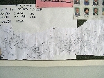 and
learn anything about local health care and
learn anything about local health care
 and health care delivery,
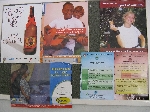
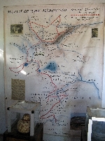
but the walls were informative with posters (several on safe sex and alcohol,
and family planning) (left) and a map of all of the villages in the district, with some
population information (right). and health care delivery,
but the walls were informative with posters (several on safe sex and alcohol,
and family planning) (left) and a map of all of the villages in the district, with some
population information (right).
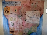
  The
Sangwali Museum is a little big museum.
The one room (one man) museum has informative exhibits on the explorations through the area
by
David Livingston, the plight of
the Helmore missionaries that settled near Sangwali,
the history of the traditional people in the area,
the Makololo, and
information on basketry .
The museum itself is not easy to find and you will need to find the curator
to get in. The curator,
Linus Makwato, is
a treasure
himself with his knowledge of local history,
enthusiasm for his endeavors and generosity to answer questions and share
it all. He has other initiatives and enterprises underway, as
well, to develop the area. The
Sangwali Museum is a little big museum.
The one room (one man) museum has informative exhibits on the explorations through the area
by
David Livingston, the plight of
the Helmore missionaries that settled near Sangwali,
the history of the traditional people in the area,
the Makololo, and
information on basketry .
The museum itself is not easy to find and you will need to find the curator
to get in. The curator,
Linus Makwato, is
a treasure
himself with his knowledge of local history,
enthusiasm for his endeavors and generosity to answer questions and share
it all. He has other initiatives and enterprises underway, as
well, to develop the area.
 Road to museum, built by Linus
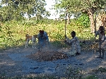
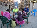
We passed a lot of the afternoon sitting under a large
tree, meeting and talking to people who came by; school teachers, local
businessmen, farmers, etc.
  Accommodations
for the night were on the porch of Ravens and his family. You know your reality
tour to an Africa village is real when the roosters wake you up crowing at 4
AM. That's reality. Get use to it. For the local residence it
is background noise that they have long since gotten used to. For the
visitors, it makes them cranky, but fortunately the tour only lasts
two-weeks and then they can go back home where all they have to deal with
are
the sounds of traffic, emergency vehicle sirens and airplane noise. Accommodations
for the night were on the porch of Ravens and his family. You know your reality
tour to an Africa village is real when the roosters wake you up crowing at 4
AM. That's reality. Get use to it. For the local residence it
is background noise that they have long since gotten used to. For the
visitors, it makes them cranky, but fortunately the tour only lasts
two-weeks and then they can go back home where all they have to deal with
are
the sounds of traffic, emergency vehicle sirens and airplane noise.
As you might have come to expect, there is yet another
language spoken in Sangwali. The dominate ethnic group here is the Mayeyi or Biyeyi who speak Shiyeyi or Maiyeyi: Good morning is "natombuka', good
afternoon is "narashara" and thank you is "takambiri." The
Mayeyi are now known as
the river people, as in the Okavongo River (and tributaries), and the dominate ethnic group in
the northern and eastern sides of the delta. After you get up on dry
land additional ethnic groups are present.
From description in the Sangwali Museum, we learn the following
history:
The Mayeyi are believed to be originally from Congo or north-west Zambia.
The language contains a series of clicks indicating an associate with the
Khoe-khoe. But it is commonly classified as close to Otjiherero (Herero),
and less frequently as close to Sisubiya and Thimbukushu, all Niger-Congo
languages. Culturally, the Mayeyi share many customs with the Mbukushu
and architecture with the Subiya and Mbukushu.
The Mayeyi, after migrating south to the area of the Chobe River and
Linyanti River, end up being pushed further south and west by the Mbukushu
and Masubiya, who were on the move west and south, respectively, in about
1750 to avoid the wrath of the expansionist Lozi. As the Mayeyi moved
southwest, along the west side of the Okavango, they encountered and clashed
with the Herero. Possibly to minimize this conflict the Mayeyi largely
settled along the rivers in the delta. David Livingstone called them river
people. He described the Mayeyi as the 'Quakers of Africa,' because of their
peace-loving nature.
The capital for the Mayeyi of this region is Sangwali. The chieftaincy is
hereditary and can be traced back to before the Lozi (a.k.a. Aluyi) and
Makolo (or Sotho) expansion and control of the area.
The Bamangwato, who are a
branch of the Tswana (named after Ngwato, one
of three sons of Malope who went their separate ways to avoid conflict in
early 1700), lived here for a short time from about
1834. Their chief Moremi, also made his capital where Sangwali now stands,
calling it Tshoroga. They had fled north from Lake Ngami when Sebetoane and
his Makololo reached the area. When the Makololo came to the Sangwali in
about 1838, they ambushed and defeated the Bamangwato and Sebetoane made
it his capital, calling it Linyanti, or Dinyanti. They controled the
region until 1864.
For a while Moremi
continued to live south of here as a subject of Sebetoane, before he
fled back to Lake Ngami with his people. That region is still dominated by
the Bamangwato.
One of the saddest chapters of Sangwali involved the Helmore mission:
(Source Sangwali Museum)
When
David Livingstone departed from
Linyanti in September 1855 to follow the Zambezi to the east coast, he
promised Chief Sekeletu of the Makololo that he would return with his wife
to set up a missionary station amongst them. However, he changed his
plans and the London Missionary Society asked Holloway Helmore to go
instead. Helmore had already been a missionary in southern Africa for 17
years.
In July 1859 Holloway
Helmore with his wife Anne, together with a second missionary Roger Price
and his wife Isabella, set off from Kuruman in the Cape, for the long
journey of approximately 6,000 km through the Kalahari to Linyanti. They
traveled in four ox wagons. The party of 21 people included the four
youngest Helmore children, a Tlhaping teacher, Thabi and some drivers and
herdsmen.
They had a terrible
journey. It was the dry season and most of the water holes had already
dried up. They suffered severely from thirst and the wagons kept breaking
down in the deep, soft sand. The oxen kept wandering away in search of
water. At a water hole in
Letlkane,
Isabella Price gave birth to a baby girl. At one stage, on the Mababe
Plain, for four nights in a row, Helmore walked 30 km to get water for the
stranded party.
Seven months later, on
14 February 1860, they arrived at Linyanti, expecting to meet
Livingstone. He had planned to make his way towards Linyanti from the
east coast, along the Zambezi River. However, he had not yet arrived, nor
had he sent word that he had been delayed. Sekeletu was not happy to
accept Helmore and Price as substitute missionaries. He was still waiting
for Livingstone and his wife to come.
Sekeletu insisted that
the party remain there, in the unhealthy swamps, until Livingstone
arrived. They had made their camp near Sekeletu’s capital, which he also
called Linyanti. This was where Malengalenga is now, about 20 km east of
Sangwali.
It was not long before
all the people in the party fell ill, and the first death occurred in 2
March 1860. Within seven weeks, eight people in the missionary party had
died at Linyanti and were buried there, including Holloway and Anne
Helmore. After Helmore’s death, Roger and Isabella Price decided to
abandon the mission and return to the Cape. Soon afterwards, on the
Mababe Plain, Isabella Price also died. The survivors, Roger Price, the
two orphaned Helmore children and eight helpers eventually arrived back at
Kuruman in February, 1861.
It is still uncertain
as to what caused their deaths. The members of the party had been plagued
by mosquitoes on their journey and most had been ill with fever. It was
not until forty years after these events that scientists discovered that
malaria was carried by mosquitoes.
However, there are
strong grounds for suspecting that Sekeletu had tried to poison them. He
did not welcome this missionary party from the south. He felt that
Livingstone and his wife Mary would be a protection against his enemy the
formidable Mzilikazi, who with his Ndebele people had settled nearby.
Mary Livingstone’s father was the famous missionary Robert Moffat, who was
greatly admired and respected by Mzilikazi.
To this day the local
people say that Sekeletu put poison from the toxic Euphorbia ingens into
the beer that he gave to the party and that he poisoned the oxen he gave
them in the same way. Price also insisted that they had been poisoned.
Perhaps we will never know the true cause of death, but most of those who
died appear to have suffered from fever and poisoning.
In 1864, the Makololo were ambushed in a
surprise raid by the Lozi under Sipopa, one of the sons of their former king, Mulambwa. The Makololo power was completely destroyed. The Lozi then became
rulers. In 1865, they appointed a headman or induna, Kabende
Simata, over the Mayeyi, Mafwe, Mbukushu and Matotela. King Sipopa was succeeded by Lewanika,
who was king from 1884 to 1916.
In the late 19th century, the British South
Africa Company took control of the region, placing it under British
protection, though Lewanika retained the right to rule the people according
to Lozi custom.
In 1909 the German Colonial Administration appointed
the Lozi Kabende Simata Mamili as chief over these people and apart from the
Mayeyi, this situation prevails to the present. Most of the Lozi now live
north of the Zambezi, in Zambia.
|
Addendum:
The
most unique items at the Sheshe Crafts Shop were a couple of piece of woven cloth (see the
border for this section of the website) that initially no one we talked to
seem to know much about.
As I gathered information it seemed to be
conflicting: One explanation was it is from Angola (which probably make it Mbukushu) and is worn by woman during traditional occasions. It is
tied around the waist so that it sits on their buttocks and bounces up and
down when they dance. Later I was told that the cloth has the Siyeyi name "mashamba."
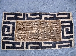
Basketry:
(Source Sangwali Museum)
Basket making among the people of southern Africa is a long-established art
in transition. An art typically handed down from one generation to the next
by the women. There is a standard of form and technique distinctive to each
ethnic group. Inter-tribally variations of design and construction
distinguish the work of one group from that of another.
The people use baskets for storage of liquids or dry
foods, agricultural activities, and transportation of food or fuel. Each of
these functions requires baskets of different shapes and construction.
Both the Bayei and the Hambukushu produce designs
featuring large, geometric patterns which are predominantly asymmetrical.
The Bayei, unlike the Hambukushu, Basotho, and Zulu
weavers, have evolved a series of symbolic patterns which are not confined
to specific families but are shared within the Bayei community. These
patterns, are called by specific names by the weavers. These names all
relate to nature. The Bayei’s constant contact with nature and perception
of animal life provided the stimulus to imitate and express those
observations in an art-form.
Perhaps the most striking design among the Bayei is the
‘Forehead of the Zebra’ (Phatla ya Pitsa). The careful observation
of the zebra with its characteristic pattern of black stripes on a whitish
background has been effectively portrayed in several pieces. The use of
heavy and thin zigzag lines, creating a pattern of movement, fills the
entire space of the containers. Each artisan, by infusing her own ideas and
imagination into the basic design, alters the pattern to some degree.
Another popular design of the region is the ‘Tail of
the Swallow’ (Sentila ya Pelwana).
The deeply curved triangular form
resembling the deeply forked tail of the swallow is arranged in a circular
pattern in the inner section of the basket. The same shape is repeated as an
ornamental border. The addition of curved lines in some of the baskets
gives an illusion of movement like the graceful swift flight of the swallow.
One of the distinct design woven by the Bayei is the
‘Knees of the Tortoise’ (Manole a Khudu), in which bold angular lines
point towards the centers of the baskets. The acute and obtuse angles of
the ‘knees’ represent joints that permit movement.
A design symbolizing an aspect of animal life is the
‘Tears of the Giraffe’ (Dikelede ya
Thutlwa) ‘Long ago the hunters would chase and shoot giraffes.
The giraffe cries before he dies and leaves a trail of tears’, weaver Digang Rasevete explains. The jagged
lines of a typical representation represent the spilt tears of the giraffe.
A simple Bayei design is referred to as ‘Urine of the
Bull’ (Moroto wa Makaba). Here, irregular, wandering lines follow
the contour of the basket in an upward direction to depict the imprinted
trail of the spilt fluid as it is left on the dry desert.
|