Ibike
USA/Canada Program
Rolling the Islands of the Salish Sea
Photo essay: Rolling the Islands of the Salish Sea: Victoria, Butchart Garden, Duncan, Vancouver Island, British Columbia.
Chemainus to VICTORIA (80km, 50mi). Explore historic settlements of
southern Vancouver Is.
Points of interest: Chemainus (town of murals), Duncan (City of Totems),
Quw’utsun’ Cultural Center, Lockside Trail, Ross Bay Cemetery,
Chinese Cemetery

Endangered Gerry Oak
 The
endangered Gerry Oak ecosystem is valued for its biodiversity. Habitat
destructions (clearing for agriculture and residential) has reduced it coverage
by 90-95% since 1850. It is becoming rare. Over 100 species of
native plants, birds, butterflies and mammals that depend on Garry oak habitat
also are now under threat, some with global extinction. The 12 hectare Cowichan Gerry Oak Reserve,
between Duncan and Oak Bay,
that we visited, is one of the largest remaining stands.
The
endangered Gerry Oak ecosystem is valued for its biodiversity. Habitat
destructions (clearing for agriculture and residential) has reduced it coverage
by 90-95% since 1850. It is becoming rare. Over 100 species of
native plants, birds, butterflies and mammals that depend on Garry oak habitat
also are now under threat, some with global extinction. The 12 hectare Cowichan Gerry Oak Reserve,
between Duncan and Oak Bay,
that we visited, is one of the largest remaining stands.

The Salish people would burn the grass lands which inhibited the expansion of the conifer forests and encouraged the Garry Oak. They would collect the acorns and then boil, steam or bake them to leach out the tannins, before eating them. The bark was used by the Saanich people to treat tuberculosis.


 The
Cowichan believe that the first people of the Cowichan came to earth from the
sky. They found a rich land, warmed by the sun and nourished with a river
teeming with salmon, which they called Quw'utsun Sta'lo'. For thousands of
years the river has provided their descendants with abundant food,
transportation and water. The Cowichan River is now designated as a
Canadian Heritage River and is part of an active local conservation program --
the water is crystal clear..
The
Cowichan believe that the first people of the Cowichan came to earth from the
sky. They found a rich land, warmed by the sun and nourished with a river
teeming with salmon, which they called Quw'utsun Sta'lo'. For thousands of
years the river has provided their descendants with abundant food,
transportation and water. The Cowichan River is now designated as a
Canadian Heritage River and is part of an active local conservation program --
the water is crystal clear..

 Quw’utsun
Cultural Center has an admission fee and information / displays on ethno-botany (how the
Salish used plants in their culture for building, tools, food and medicine),
a number of story poles with signage to explain their context, meaning and
purpose, a collection of canoes, theatre, exhibits, cafe and gift shop.
Quw’utsun
Cultural Center has an admission fee and information / displays on ethno-botany (how the
Salish used plants in their culture for building, tools, food and medicine),
a number of story poles with signage to explain their context, meaning and
purpose, a collection of canoes, theatre, exhibits, cafe and gift shop.The most informative and engaging of the offering is the half-hour guided tour lead by a Cowichan elder and story teller.
1. Welcoming pole
2. Longhouse entry door pole.
3, Marriage pole.
4. Chief Tzouhalem pole
5. Guardian pole
6. Raven, Sun & Medicine Woman
7.Tzonokwa (Wild Woman)
8. Thunderbird Returning the Salmon
9. Thunderbird and Child


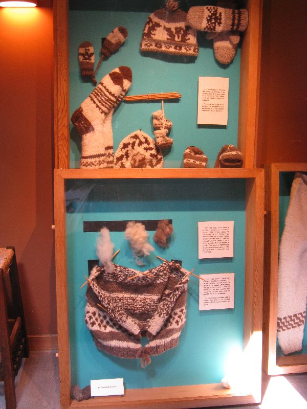
 One
exhibit is on Cowichan sweaters, a traditional craft of the Cowichan people, which are
hand-knitted in one piece. The fleeces come in natural colors and shades
of brown, black and white. Genuine Cowichan sweaters are still highly prized and
continue to be produced in the Cowichan Valley. No two sweaters are
exact;y alike.
One
exhibit is on Cowichan sweaters, a traditional craft of the Cowichan people, which are
hand-knitted in one piece. The fleeces come in natural colors and shades
of brown, black and white. Genuine Cowichan sweaters are still highly prized and
continue to be produced in the Cowichan Valley. No two sweaters are
exact;y alike.
Procuring and processing raw wool for knitting originally involved up to five steps: shearing, washing and drying, hand teasing, hand carding, loosely twisting and spinning with a spindle and whorl. Today, many knitters purchase spin-ready commercially carded wool and spin it on motorized spinning wheels.

Bicycle art, Cowichan Bay, BC
 selection of hearty bread and one would need
advance degrees to understand every thing available in the cheese shop.
But what really stood out was the bicycle art on the front steps (left)!
selection of hearty bread and one would need
advance degrees to understand every thing available in the cheese shop.
But what really stood out was the bicycle art on the front steps (left)!
 Away from the
tourist village, the
roadside views alternate between farmland and forest. The farmland offers
bigger vistas, but the forest seem more comforting and calm. They are also
cooler and pleasant places to stop, relax and regroup.
Away from the
tourist village, the
roadside views alternate between farmland and forest. The farmland offers
bigger vistas, but the forest seem more comforting and calm. They are also
cooler and pleasant places to stop, relax and regroup.

 The "backroad"
into Victoria requires a ferry boat ride from the "mainland" of Vancouver
Island, across Mill Bay to Brentwood on the Saanich Peninsula. Much of the
Saanich Peninsula is still rural enough to have active agriculture and horse
farms. As residential communities like Brentwood expand farms are being
absorbed, roads are being widened to accommodate the increased traffic, and
shopping centers are being splayed out into forests and over top soil.
The "backroad"
into Victoria requires a ferry boat ride from the "mainland" of Vancouver
Island, across Mill Bay to Brentwood on the Saanich Peninsula. Much of the
Saanich Peninsula is still rural enough to have active agriculture and horse
farms. As residential communities like Brentwood expand farms are being
absorbed, roads are being widened to accommodate the increased traffic, and
shopping centers are being splayed out into forests and over top soil.
Butchart Gardens

 The shore of Mill
Bay is also the location of Butchart Gardens. It is 55 acres of carefully landscaped, meticulously weeded and prunes, and generally
over indulged gardens of a half dozen styles (Bagonia, sucken, rose,
Japanese, Italian, and wooded). It is easy to get absorbed and spend
several hours wander through the fields and forests of foliage
The shore of Mill
Bay is also the location of Butchart Gardens. It is 55 acres of carefully landscaped, meticulously weeded and prunes, and generally
over indulged gardens of a half dozen styles (Bagonia, sucken, rose,
Japanese, Italian, and wooded). It is easy to get absorbed and spend
several hours wander through the fields and forests of foliage
 In its former life, until
1904, what is now the sunken garden was a limestone quarry for a cement plant on
part of the estate of the business' owners,
Robert P and Jennie Butchart.
In its former life, until
1904, what is now the sunken garden was a limestone quarry for a cement plant on
part of the estate of the business' owners,
Robert P and Jennie Butchart.

Sunken rock garden
 The
sunken rock garden
is the original bleak limestone pit. To refurbish it Mrs. Butchart had
tons of top soil hauled in from local farms by horse cart and line the floor of
the pit. From there she started designing and planting her garden.
The
sunken rock garden
is the original bleak limestone pit. To refurbish it Mrs. Butchart had
tons of top soil hauled in from local farms by horse cart and line the floor of
the pit. From there she started designing and planting her garden.The other gardens were added over the century, after the initial development of the sunken garden.


 Spring
colors include;
heavily manipulated hydrangea (far left) and not your so ordinary purple tulips
(right), and ever showy flowering cherry trees (left).
Spring
colors include;
heavily manipulated hydrangea (far left) and not your so ordinary purple tulips
(right), and ever showy flowering cherry trees (left).
 The
ethnic theme gardens include a Japanese Garden (left) and formal Italian Garden.
There is also the Star Pond (right), which was originally designed for Mr.
Butchart's collection of ornamental ducks.
The
ethnic theme gardens include a Japanese Garden (left) and formal Italian Garden.
There is also the Star Pond (right), which was originally designed for Mr.
Butchart's collection of ornamental ducks.
Lockside Trail

 We approached Victoria on the Lockside Trail, which links
Sydney and Victoria. In Victoria the Lockside Trail connections with the Galloping
Goose. The Lockside Trail trail snake you into and through Victoria by such a beautiful and serene
route that you hardly know that are piercing through residential sprawl and urbanization.
We approached Victoria on the Lockside Trail, which links
Sydney and Victoria. In Victoria the Lockside Trail connections with the Galloping
Goose. The Lockside Trail trail snake you into and through Victoria by such a beautiful and serene
route that you hardly know that are piercing through residential sprawl and urbanization.
Inner Harbor
 The trails lead you to Victoria's Inner Harbor
on old Selkirk Trestles built for railroads.
In 1842, James
Douglas selected Camosack, as it was then known, as the site for the Hudson Bay Company
(HBC) trading post,
Fort Victoria. In 1858, gold was discovered in the Fraser River
Valley on the main land
and Victoria grew as supply depot. The HBC also lost its monopoly and commerce
became more lively for a few years.
The trails lead you to Victoria's Inner Harbor
on old Selkirk Trestles built for railroads.
In 1842, James
Douglas selected Camosack, as it was then known, as the site for the Hudson Bay Company
(HBC) trading post,
Fort Victoria. In 1858, gold was discovered in the Fraser River
Valley on the main land
and Victoria grew as supply depot. The HBC also lost its monopoly and commerce
became more lively for a few years.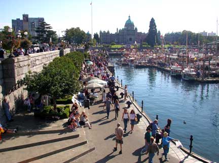
More Inner Harbor
 To build the fort, Douglas' men had to negotiate a muddy shore and clear a dense
forest. A large part of the bay's muddy tide flats has now been filled and much of the rest
dredged. The southeast corner of the bay is now ringed by a promenade,
which on sunny summer days is lined with artists and craft merchants and packed
with a stream of tourists.
To build the fort, Douglas' men had to negotiate a muddy shore and clear a dense
forest. A large part of the bay's muddy tide flats has now been filled and much of the rest
dredged. The southeast corner of the bay is now ringed by a promenade,
which on sunny summer days is lined with artists and craft merchants and packed
with a stream of tourists. 
Heritage building
 After the provincial capital of British Columbia
was moved to Victoria in 1868, its long term survival was pretty well assured,
but for most the next century it was on a slow growth program.
That, in fact, might have been to its benefit because now there are about 15 square
blocks of heritage building, most dating from 1880 to 1900.
After the provincial capital of British Columbia
was moved to Victoria in 1868, its long term survival was pretty well assured,
but for most the next century it was on a slow growth program.
That, in fact, might have been to its benefit because now there are about 15 square
blocks of heritage building, most dating from 1880 to 1900.


Bastion Square
 Bastion Square
(left) was
initially the center of Fort Victoria.
After the destruction of the fort, the land was sold off in lots. Commercial development floundered for 50 years.
It took a hundred year, but the area is again a fashionable address for office
space and on sunny days the square is an ongoing street fair packed with
merchants, entertainers and hopefully tourist.
Bastion Square
(left) was
initially the center of Fort Victoria.
After the destruction of the fort, the land was sold off in lots. Commercial development floundered for 50 years.
It took a hundred year, but the area is again a fashionable address for office
space and on sunny days the square is an ongoing street fair packed with
merchants, entertainers and hopefully tourist.
Gate of Harmonious Interest
 The Gate of Harmonious
Interest announces Victoria's Chinatown, though it is more in the center than at
any entrance. Gold-rush era Chinese from San Francisco & China established Canada's first
Chinatown; with shops & rooms, gambling and opium dens, bars & brothels,
employment agencies and family associations..
The Gate of Harmonious
Interest announces Victoria's Chinatown, though it is more in the center than at
any entrance. Gold-rush era Chinese from San Francisco & China established Canada's first
Chinatown; with shops & rooms, gambling and opium dens, bars & brothels,
employment agencies and family associations.. 
 south and
Chinatown to the north. During the 1880s, the wooden shacks on the north side of
the ravine were replaced with utilitarian commercial blocks. During the
1880s and 90s, hotels were built on the south side. The inner courtyard
was used to support the business that faced the street. From 1930 to 1970
the area fell into serious decay. As a backlash to the demolish of
historic buildings the buildings were protected, restored and opened as Market
Square in 1976. The interior still has a lot of open space, restaurants
with outside eating and it is frequently the venue for live music.
south and
Chinatown to the north. During the 1880s, the wooden shacks on the north side of
the ravine were replaced with utilitarian commercial blocks. During the
1880s and 90s, hotels were built on the south side. The inner courtyard
was used to support the business that faced the street. From 1930 to 1970
the area fell into serious decay. As a backlash to the demolish of
historic buildings the buildings were protected, restored and opened as Market
Square in 1976. The interior still has a lot of open space, restaurants
with outside eating and it is frequently the venue for live music.
 While the preservation of historic buildings gives downtown Victoria a lot of it
character there are gems of modernity to find as well: One is the new
Victoria Public Library. It actually incorporates two pre-existing
structures and has several piece of noteworthy art. Just off the street,
signaling the library, is a very inspiring, life-size, bronze sculpture of
children reading books by
Marianne Caroselli (sorry no photo). In the atrium is George
Norris's four story tall Dynamic Mobile Steel
Sculpture (left). A second large piece is the Centennial Square Fountain
(right). It was a gift to Victoria from Esquimalt to Commemorate the centenary
of progress.
While the preservation of historic buildings gives downtown Victoria a lot of it
character there are gems of modernity to find as well: One is the new
Victoria Public Library. It actually incorporates two pre-existing
structures and has several piece of noteworthy art. Just off the street,
signaling the library, is a very inspiring, life-size, bronze sculpture of
children reading books by
Marianne Caroselli (sorry no photo). In the atrium is George
Norris's four story tall Dynamic Mobile Steel
Sculpture (left). A second large piece is the Centennial Square Fountain
(right). It was a gift to Victoria from Esquimalt to Commemorate the centenary
of progress.
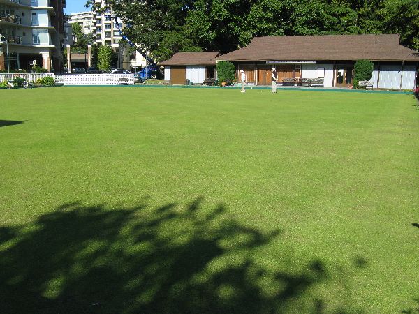 A block behind the hotel is the
bowling green of that most quintessential British game, lawn bowling. This
is the home of the Canadian Pacific Lawn Bowling Club. White treads are
preferred by players, but truth be told, all you really need to lawn bowl is a
"jack" (the little white target ball) and set of bowls (this is their correct
name for the special orbs that are delivered down the rink.)
A block behind the hotel is the
bowling green of that most quintessential British game, lawn bowling. This
is the home of the Canadian Pacific Lawn Bowling Club. White treads are
preferred by players, but truth be told, all you really need to lawn bowl is a
"jack" (the little white target ball) and set of bowls (this is their correct
name for the special orbs that are delivered down the rink.)

 The
other grand building on the inner harbor is the B.C. Provincial Parliament
building (1893-97). It is categorized as Free Classical style and contains the
first rotunda in Canada -- probably inspired by the U.S. Capitol. At night it
is outlined with 3000 lights. The lead architect on the building
was 25 year old Francis Rattenbury. Rattenbury was also the architect for the Empress
Hotel, Crystal Gardens, the CPR Steamship Terminal, the Court House in
The
other grand building on the inner harbor is the B.C. Provincial Parliament
building (1893-97). It is categorized as Free Classical style and contains the
first rotunda in Canada -- probably inspired by the U.S. Capitol. At night it
is outlined with 3000 lights. The lead architect on the building
was 25 year old Francis Rattenbury. Rattenbury was also the architect for the Empress
Hotel, Crystal Gardens, the CPR Steamship Terminal, the Court House in Bastion Square and the Bank of Montreal..

Thunderbird Park


 Further
west on the south shore, leaving the Inner Harbor and siding up to the Middle
Harbor, you emerge from the tourist zone and the density of people thins
considerable. Here you will find part of Victoria's quaint, colorful and
small houseboat neighborhood (ala "Sleepless In Seattle") and Victoria's
Fisherman's Wharf, the moorage for the harbor's romantic and diminutive fishing
fleet.
Further
west on the south shore, leaving the Inner Harbor and siding up to the Middle
Harbor, you emerge from the tourist zone and the density of people thins
considerable. Here you will find part of Victoria's quaint, colorful and
small houseboat neighborhood (ala "Sleepless In Seattle") and Victoria's
Fisherman's Wharf, the moorage for the harbor's romantic and diminutive fishing
fleet.Continuing around the perimeter of the James Bay neighborhood you reach the outer harbor and then open water.

 the originally name, by the First Nations people, was Meeacan (the Salish name for
belly) because from a distance, it looked like the
belly of a large man lying on his back. It is home to panoramic views of the Straights and Olympic Mountains
(caveat here -- on a clear day), a two-story tall, user activated, watering can
/ fountain / sprinkler (right), a kids petting farm, various ponds,
streams, paths, foot bridges, gardens, lawns and glens, and Mile "0" of the
Trans-Canadian Hwy.
the originally name, by the First Nations people, was Meeacan (the Salish name for
belly) because from a distance, it looked like the
belly of a large man lying on his back. It is home to panoramic views of the Straights and Olympic Mountains
(caveat here -- on a clear day), a two-story tall, user activated, watering can
/ fountain / sprinkler (right), a kids petting farm, various ponds,
streams, paths, foot bridges, gardens, lawns and glens, and Mile "0" of the
Trans-Canadian Hwy.
 This
spindle is one of seven "Signs
of Lekwungen" set in Victoria telling some of the story of the Lekwunge people,
the First Nation people occupying the land at the time of contact with
Europeans. The information says the
hill was called MEE-qan and gives the meaning as "warmed by the surf". A field here was used
to play Coqwialls, which is similar to field hockey. At the bottom of the hill
was a small, palisaded village that was occupied intermittently from 1,000 until
300 years ago. It was used for defense during times of war and it was important
site
for reef net fishing. Camas was gathered in the area.
This
spindle is one of seven "Signs
of Lekwungen" set in Victoria telling some of the story of the Lekwunge people,
the First Nation people occupying the land at the time of contact with
Europeans. The information says the
hill was called MEE-qan and gives the meaning as "warmed by the surf". A field here was used
to play Coqwialls, which is similar to field hockey. At the bottom of the hill
was a small, palisaded village that was occupied intermittently from 1,000 until
300 years ago. It was used for defense during times of war and it was important
site
for reef net fishing. Camas was gathered in the area.
World's tallest totem pole, Beacon Hill Park, Victoria

Chinese cemetery, Ross Bay, Victoria
 Bought by the Chinese
Consolidated Benevolent Association in 1903, to replace a low lying plot along
Ross Bay. The Chinese cemetery site was chosen using the principles of Feng Shui
(literally, wind and water). The cemetery site is flanked by the "Azure
Dragon (Qinglong) on its left and by the "White Tiger" (Baihu) on its right, and
backed with a "Pillow Mountain" (Zhenshan, Gonzales Hill), where the two cosmic
forces of Dragon and Tiger converse. It is embraces by the "Living Water"
(McNeil Bay) (Shengshui, symbol of wealth) There is a giant incense burner
in the middle.
Bought by the Chinese
Consolidated Benevolent Association in 1903, to replace a low lying plot along
Ross Bay. The Chinese cemetery site was chosen using the principles of Feng Shui
(literally, wind and water). The cemetery site is flanked by the "Azure
Dragon (Qinglong) on its left and by the "White Tiger" (Baihu) on its right, and
backed with a "Pillow Mountain" (Zhenshan, Gonzales Hill), where the two cosmic
forces of Dragon and Tiger converse. It is embraces by the "Living Water"
(McNeil Bay) (Shengshui, symbol of wealth) There is a giant incense burner
in the middle.
 My
last meal before pedaling out of Victoria was at Café Bliss (left). In
their own words, "100% organic, 100% raw, 100% vegetarian and vegan, 100% wheat
and gluten free, 100% fresh and local ingredients, 100% made with love." I
will add very delicious.
My
last meal before pedaling out of Victoria was at Café Bliss (left). In
their own words, "100% organic, 100% raw, 100% vegetarian and vegan, 100% wheat
and gluten free, 100% fresh and local ingredients, 100% made with love." I
will add very delicious.
![]()
![]()


 Please
contact us if you would like to be added to
Ibike's mailing list or have questions, comments, corrections or criticism. (Also, please let us know how you learned about us and
found this site.) Privacy policy.
Please
contact us if you would like to be added to
Ibike's mailing list or have questions, comments, corrections or criticism. (Also, please let us know how you learned about us and
found this site.) Privacy policy.
![]() IBF Homepage
IBF Homepage ![]() Ibike Programs
Ibike Programs
![]() Ibike Schedule
Ibike Schedule
![]() Search
Search