| Andes to Amazon | |||
| Ibike Ecuador | |||
| Dispatch 8 - Puyo | |||

|
 To hear
some Ecuadorians talk about it, Ecuador is suppose to be the
greatest bicycling anywhere in the world and Banos to Puyo is supposed to be
the best bicycle ride in Ecuador. I am all for national pride, and while
Ecuador has some outstanding
features for bicycling, I am not sure I would necessarily agree with either
assertion. To hear
some Ecuadorians talk about it, Ecuador is suppose to be the
greatest bicycling anywhere in the world and Banos to Puyo is supposed to be
the best bicycle ride in Ecuador. I am all for national pride, and while
Ecuador has some outstanding
features for bicycling, I am not sure I would necessarily agree with either
assertion.. |
 |
|
 |
Between
2005-10 the route was significantly improved were made for
bicycling. Prior to the improvements there was one, at times very narrow
dirt road for all of the traffic. The main element of the improvements was
the construction of a half dozen tunnel and many miles new roads for motor
vehicle. This left the old trail on the edge of the canyon exclusively for
bicyclists and pedestrians. I was also improved as well with better
drainage, signage and an assortment of hard riding surfaces. |
 |
|
 |
Banos to Puyo
is probably prettier on a prettier
day. When I have been there it has always been heavy gray and overcast most of the day and sprinkling or pouring a
lot of it. Whether the moisture was coming from the top, the bottom
or the sides, it kept us damp. Because part of the route is dirt,
bodies and equipment get a gray clay veneer by the time we reached Puyo.
|
 |
|
 |
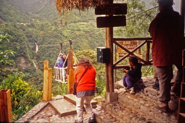
What
is interesting and nice about the leg? The Rio Pastaza Canyon: the river
itself; waterfalls coming off of both walls of the valley, including over
the road; raging rivers, fueled by the heavy over night down pours,
cascading out of the side valleys; unlighted
tunnels; a hydro electric dam and power station; Ecuador's longest cable
car suspended hundreds
of
feet above the Rio Pastaza; and the nearly continuous decent for 20 km. |
 |
|
 |
With
the decent the climate and environment changed; the temperature got
warmer, the humidity went up and the vegetation was more lush. It was
starting to feel tropical. The setting, vegetation, small town
architecture and speed of life all evoked memories of rural Cuba.
The first major town in the more tropical zone is Shell. It is said to be
name after the Royal Dutch Shell oil company. Connecting the dots, it
was probably founded during the exploration for petroleum (1920-1940). The
boom died until the current oil boom in Oriente, which started in the 1970s. |
 |
|
 |
As the Pastaza river emerges from the foot of the eastern slope of the Andes the land becomes more rolling, the rivers drop less quickly and become less angry -- almost smooth for sections. The commercial center for the region is el Puyo or just Puyo (poncho). |
 |
|

|
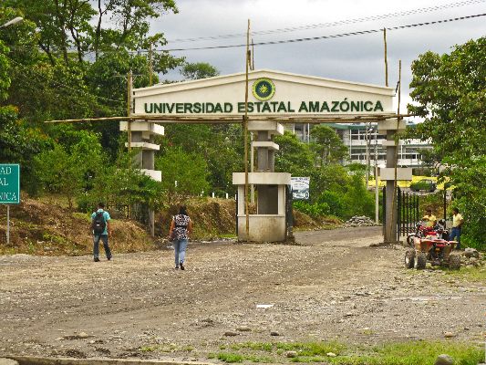
 Like
many towns in Ecuador, Puyo has added some new class in the first decade of the
millennium. The economy as represented in the retail streets look
healthier (more diverse, more range and high quality), there is quality public
art (photo left: day and night), more cultural
institutions (like the museum described below), more Like
many towns in Ecuador, Puyo has added some new class in the first decade of the
millennium. The economy as represented in the retail streets look
healthier (more diverse, more range and high quality), there is quality public
art (photo left: day and night), more cultural
institutions (like the museum described below), more restaurants with a wider range of dishes (to the right is a sample menu), park
development (see below) and in the case of Puyo, a new university campus (left).
restaurants with a wider range of dishes (to the right is a sample menu), park
development (see below) and in the case of Puyo, a new university campus (left). |

|
|
 |
In the center of Puyo is a small, efficient Ethno Archeological Museum. There is not a lot of explanatory text, but it has exhibits of traditional pottery (left), stone tools (right), butterflies and spiders (right), anaconda (snake) skins (below, right), and shelters from local ethnic groups (below), which are filled with various items of material culture, presumably from the respective ethnic groups. There is no admission fee so it is always worth a look. |
 |
|
 |


 |
 |
|
 |
 A
small river by the same name runs through Puyo. The uplands have been
developed into a park with public art, a riverside trail (bicycle prohibited),
an ethno botanical garden, restaurants and up-scale hotels. If you visit
the botanical garden with a sore, the director will help you purchase a natural
antiseptic lotion to treat it with. A
small river by the same name runs through Puyo. The uplands have been
developed into a park with public art, a riverside trail (bicycle prohibited),
an ethno botanical garden, restaurants and up-scale hotels. If you visit
the botanical garden with a sore, the director will help you purchase a natural
antiseptic lotion to treat it with. |
 |
|
| While there is not much Western civilization beyond Puyo there are a number of interesting indigenous ethnic groups that can be enriching destinations for the engaged traveler who wants to make the effort. Some of these are south of Puyo. There are a couple of profile here: One to the Shuer people around Paloma and Otto, and the other to Pastazas Quichua people in Canelos. | |||
|
|
|||
   
|
|||
|
|
|||
|
"Hosted by
DreamHost - earth friendly web hosting"
|
|||

 Please
contact us
Please
contact us