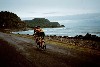
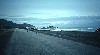
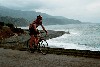
 Above us to the
north and in the clouds, are the Sierra Maestra, Mt Turquino, 6749 ft,
the highest point in Cuba and the cloud shrouded, mountain fortified
headquarters of the Liberation Army. To the south is the Caribbean
Sea, plunging to a depth of 23,179 feet in the Cayman Trench not far
away. There is generally not much in between except a ledge for
the road so the scenery is very dramatic -- even with the heavy cloud
cover. Many considered this the most spectacular road they had
ever ridden, surpassing Big Sur.
Above us to the
north and in the clouds, are the Sierra Maestra, Mt Turquino, 6749 ft,
the highest point in Cuba and the cloud shrouded, mountain fortified
headquarters of the Liberation Army. To the south is the Caribbean
Sea, plunging to a depth of 23,179 feet in the Cayman Trench not far
away. There is generally not much in between except a ledge for
the road so the scenery is very dramatic -- even with the heavy cloud
cover. Many considered this the most spectacular road they had
ever ridden, surpassing Big Sur.
At the start of the revolution Batista had some garrisons in towns
like El Jigue. These were vulnerable to surprise attacks, which
the Liberation Army took advantage of. In 1957, Fidel's troops
attacked El Jigue, on the La Plata River, for one of their first decisive
victories and an important opportunity to increase and upgrade their
firepower.
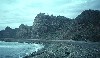
Another relic of military activity along the coast is caves dug
straight into the bedrock. These were to house and protect tanks
that used to be stationed along the coast in case of attack. The
Cubans pointed out that these were purely defensive and that Cuba has
no significant offensive capability.
Somewhat in the same vein, by some Cuban count, there have been
over 300 assassination attempts against Fidel and Cuba has never been
involved in aggression against any other country. No question
that Fidel has been the target of dirty tricks, but I don't have
enough information to believe that they have averaged one every month
and a half.
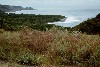
Along the way we passed thatched huts called bohíos
and saw coffee growing on mountain slopes. The farmers' compounds were
spotless. Dogs, pigs and chickens ate every smidgen of organic matter
and what they left was swept clean daily.


