| Ethiopia:
Abyssinia Adventure - Hwy 3: West Tigray Province Bicycle Africa / Ibike Tours |
|||
 |
Self-contained bicycle tour through western Tigray Province. This tour passes through rugged, spectacular countryside and samples some of the wonderful hospitality of the region. | ||
 |
|||
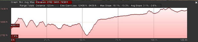
| [Graphs are built with incomplete data and are only general representations
of the topography.] |
|||
| For the government of
Ethiopia, Tigray Province starts at the 'Buya' River, geologically the Simien
Mountain topography ends at Zarima, and hundreds of kilometers of plateau sliced
by river valley begins. This is indicative of western Tigray. |
|||
 |
 Most
of the road is new asphalt from Zarima to Axum. That is cause for celebration. The Ethiopian Road Authority (ERA)
project sign lists the project duration as three years and the completion date
as October 2012. It wasn't too long before it was clear that in December 2015
they still had hillside to stabilize, bridges to build and sections of roadway
to pave. But for the most part the road was asphalt and an immeasurable
improvement to Italian rock road. Bravo to the ERA. Most
of the road is new asphalt from Zarima to Axum. That is cause for celebration. The Ethiopian Road Authority (ERA)
project sign lists the project duration as three years and the completion date
as October 2012. It wasn't too long before it was clear that in December 2015
they still had hillside to stabilize, bridges to build and sections of roadway
to pave. But for the most part the road was asphalt and an immeasurable
improvement to Italian rock road. Bravo to the ERA. |
||
 |
 The
lower elevation, warmer climate (almost tropical) and water supply of the Zarima or Dukoko
River, enable growing banana,
mango and riverside vegetable gardens at Zarima, elevation 1220m. The
lower elevation, warmer climate (almost tropical) and water supply of the Zarima or Dukoko
River, enable growing banana,
mango and riverside vegetable gardens at Zarima, elevation 1220m. |
 |
|
 |


 |
 |
|
 |
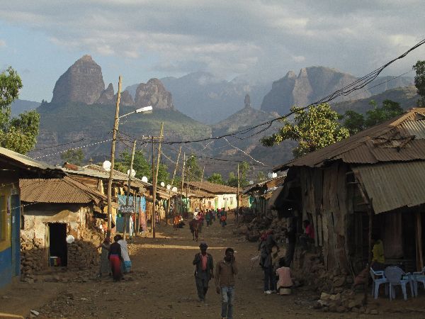
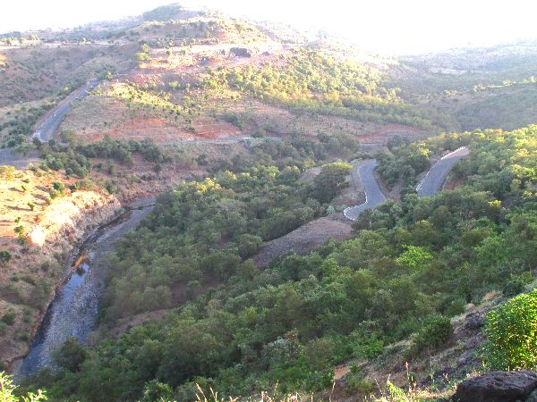
A
lot of reality of the next section is expressed in number; kilometers travel and
elevation gained and lost. From Zarima to
Golima is about 13 kilometers of asphalt road and 500m vertical. rise (in 9km), as the road weaves and winds up the
plateau the view are BIG, and
the switchbacks are seemingly endless. Say what you might about
switchbacks, but the lengthen the the distance, thereby decreasing the grade,
yet they make you feel like you are making progress and being successful, which
is a moral boost. These students (left) have this view every day they walk to and from school. |
 |
|
 |
  The
hill to the north of Golima is another 500m in 6km from ridge to river. As an
aside, it is very difficult to find the names of rivers and other geographical
features in Ethiopia. The
hill to the north of Golima is another 500m in 6km from ridge to river. As an
aside, it is very difficult to find the names of rivers and other geographical
features in Ethiopia. |
||

 To reach the next ridge the climb is about 400m,
in 6km, which brings you to Bere
Mariyam. Bere Mariyam is the name on the town placards on the road. If you want
to find it on a map look for 'Chew Ber'. And as with many Ethiopan place names,
there may be a variety of spells. To reach the next ridge the climb is about 400m,
in 6km, which brings you to Bere
Mariyam. Bere Mariyam is the name on the town placards on the road. If you want
to find it on a map look for 'Chew Ber'. And as with many Ethiopan place names,
there may be a variety of spells. |
|||
| As the old rock lyrics say, "What goes up must come down, spinning wheels got to go round." From Bere Mariyam to the bottom of the next river valley is 400m, over six kilometers. And then most of that has to regained to reach the next ridge at Adi Arkay. Adi Arkay has one of the prettiest settings for a town any where. Massive rock mountains dominate the landscape. | |||


 |
|||
  The
center of Adi Arkay is dominated by a large tree. Under the tree a pool
hall / bar has been constructed. It is noteworthy that pool tables, which are
not cheep or light have made it to every town in Ethiopia, in multiples, and
they are rarely idle. The
center of Adi Arkay is dominated by a large tree. Under the tree a pool
hall / bar has been constructed. It is noteworthy that pool tables, which are
not cheep or light have made it to every town in Ethiopia, in multiples, and
they are rarely idle. |
 |
||
 |
 Throughout
the early even things happened as the town move through it paces: Besides
regular business at the coffee shops, the water truck rolled up the road
irrigating the young street trees in the median. About 4:30 a column of students
poured out of the school, gradually peeling away in small groups to the own
personal destinations. At the church, the faithful approached for a few minutes
of pray and then moved on. Throughout
the early even things happened as the town move through it paces: Besides
regular business at the coffee shops, the water truck rolled up the road
irrigating the young street trees in the median. About 4:30 a column of students
poured out of the school, gradually peeling away in small groups to the own
personal destinations. At the church, the faithful approached for a few minutes
of pray and then moved on. |
 |
|
 |
 Adi
Arkay is at a high point so the next path is down. This time a rather modest
250m drop over 4km to another river. The added dimension here is it is most of
the day is below 1500m so the mornings are fresh, but by 10:00 it is getting
warm enough to add extra stress to every climb. Adi
Arkay is at a high point so the next path is down. This time a rather modest
250m drop over 4km to another river. The added dimension here is it is most of
the day is below 1500m so the mornings are fresh, but by 10:00 it is getting
warm enough to add extra stress to every climb.In the Ethiopian, December temperature profile at 3000m it is cold, at 2500m it is comfortable, at 2000m afternoons are hot for climbing, and at 1500m any climb past early morning will leave you sweating profusely. |
 |
|


 |
|||
|
After the river the ribbon of road does a little bouncing up 150m in 3km, with
4km rolling up and down on a plateau book ended by ridges, before taking another 300m descent over
8km to Buya. Not bad by western Tigray standards and the scenery is gorgeous.
The river at Buya is the boundary between Amhara and Tigray Provinces. I was
told that it is called the Buya River, but communication was a little muddled
and I am not certain the village and river share a name. The name does not
appear in any list of rivers in Ethiopia or as a tributary of the Tekeze River (aka
Takane River), of which this river is a seasonal contributor. |
|||
  Having
arrived at another low spot, another climb is in store. The change here is about
250m over a few kilometers, before reach a plateau that extends to May Ts'ebri,
the May Ayni refugee camp and the village of Imba Madre. The total distance from
the river to Imba Madre is 27 km. Having
arrived at another low spot, another climb is in store. The change here is about
250m over a few kilometers, before reach a plateau that extends to May Ts'ebri,
the May Ayni refugee camp and the village of Imba Madre. The total distance from
the river to Imba Madre is 27 km. |
|||
| I am not a fan of refugee-camp-tourism, but the May Ayeni refugee camp straddles the highway so here are observations from only the snapshot available passing through: | |||


 |
|||
|
|||


 |
|||
|
|||
 |
 Between the Adi Arkay plateau and the Tekezé River there are
600m of elevation difference. The Tekezé River forms in the highlands near Lasta
(think Lalibela), from where it flows west, north, then west again, forming the
westernmost border of Ethiopia and Eritrea from the confluence of the Tomsa with
the Tekezé to the tripoint between the two countries and Sudan . After entering
northeastern Sudan at the tripoint it joins the Atbarah River (It rise 30km west
of Gondar and makes a short run north, then west and then north again. It is a
tributary of the Nile. The Tekezé is perhaps the true upper course of the
Atbarah, as the former follows the longer course and has a higher volume of
water prior to the confluence of the two rivers. At the point that the road
crosses the Tekezé it is about 850m above sea level. Between the Adi Arkay plateau and the Tekezé River there are
600m of elevation difference. The Tekezé River forms in the highlands near Lasta
(think Lalibela), from where it flows west, north, then west again, forming the
westernmost border of Ethiopia and Eritrea from the confluence of the Tomsa with
the Tekezé to the tripoint between the two countries and Sudan . After entering
northeastern Sudan at the tripoint it joins the Atbarah River (It rise 30km west
of Gondar and makes a short run north, then west and then north again. It is a
tributary of the Nile. The Tekezé is perhaps the true upper course of the
Atbarah, as the former follows the longer course and has a higher volume of
water prior to the confluence of the two rivers. At the point that the road
crosses the Tekezé it is about 850m above sea level. |
 |
|
  The
Ethiopian Road Authority has decorated a retaining wall on the hill. Part of it
shows a variety of traffic signs, and the other half noteworthy sites in
Ethiopia; the Simien Mountains, Fasilidas Castle Gondar, Rock hewed churches
Lalibela, Abaya Dam and a train. The
Ethiopian Road Authority has decorated a retaining wall on the hill. Part of it
shows a variety of traffic signs, and the other half noteworthy sites in
Ethiopia; the Simien Mountains, Fasilidas Castle Gondar, Rock hewed churches
Lalibela, Abaya Dam and a train. |
|||
 |
  The
Tekezé River carries water that doesn't get to the parched surrounding
countryside. The climate and remoteness of the area is nicely illustrated by the
two camels and their jockeys fording the river. The
Tekezé River carries water that doesn't get to the parched surrounding
countryside. The climate and remoteness of the area is nicely illustrated by the
two camels and their jockeys fording the river.The vicinity of the Tekezé is
one of the section that road improvement have yet to arrive and the bridge looks
like it was constructed decades ago with an industrial size Erector Set (for
those who aren't familiar with this classic engineering and construction toy, it
still has a presence on the Internet.) |
 |
|
 If
you play the old classic rock song backwards it must say, "What goes down must
go up, spinning wheel must go round, but oh so very slowly." The next iteration
of inclined plane, between the Tekezé River and Adi Gebru, zigzags across the
mountainside for 13km and transports the traveler 800m higher. The combination
of low elevation, reflective hillsides and high sun raised the temperature to
sweat spurting levels -- drink plenty of water and it is a cleansing process.. If
you play the old classic rock song backwards it must say, "What goes down must
go up, spinning wheel must go round, but oh so very slowly." The next iteration
of inclined plane, between the Tekezé River and Adi Gebru, zigzags across the
mountainside for 13km and transports the traveler 800m higher. The combination
of low elevation, reflective hillsides and high sun raised the temperature to
sweat spurting levels -- drink plenty of water and it is a cleansing process..I
couldn't help to note that while every steep slope sign in Amhara Province was
for 7% (which was Mid-hill a UNHCR truck passed, heading toward
May Ayeni. It had at least a dozen people in the back. There is no simple way of
knowing their stories. |
|||
 |
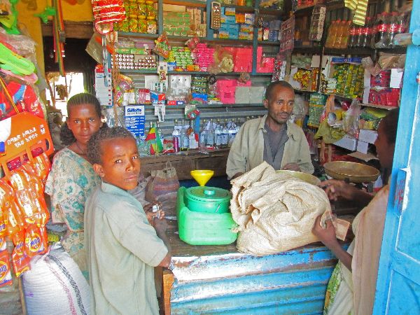
Adi Gebru provided a welcome location for re-hydration and a caloric intake --
in the form of bread and peanut butter. Eye catching in Adi Gebru is the colorful store fronts. One strategy when children start to crowd uncomfortable close is to pull out a camera and start taking picture. Often they group will back off a little and calm down. But it can also go the other way where everyone starts mugging for the camera, wants their picture taken and want to see it on the digital screen. This may be a near riot. In any case the operation went pretty well during the reststop in Adi Gebru. |
 |
|


 |
|||
 |
Top of the plateau! Who knew it could happen, but the segment from Adi Gebru,
through Inda Aba Guna, to Shire only rise 300m over about forty kilometers.
There might actually be a word for "flat" in Tigrinya. |
||

|
Added to donkeys as pack animals were camels. They are used to haul construction
materials like poles, rocks and gravel. |
 |
|
 |
It seems that the way to meet local, English speakers, is to find group of older men at a bar or coffee house in the afternoon, with nicely cut Western cloths. If they were drinking beer the optimal number was three bottles per participant. Regardless, if there was an English speaker among the group I was often invited to join them and they always had plenty of questions to keep the conversation going. Versions of this formula worked several times. | ||
 Shire
has had a main street modernization treatment, like so many towns in Ethiopia.
Theirs must have been one of the earlier ones because the trees are more mature.
In addition to sidewalks, curbs, a median and trees, Shire also has street
lights. Shire
has had a main street modernization treatment, like so many towns in Ethiopia.
Theirs must have been one of the earlier ones because the trees are more mature.
In addition to sidewalks, curbs, a median and trees, Shire also has street
lights.A nice touch in the boutique hotel was a cloth rose on the bed. Unlike the main and more expensive hotel in town, it had WiFi in the rooms, not just in the lobby area. |
 |
||
 |
The traffic circle in Shire is dominated by local hero Major General Hadush "Hayelom" Araya (1955-1996). General Hayelom is a former member of the Tigrayan Peoples' Liberation Front (TPLF), which overthrew the Derg, and is the leading member of the Ethiopian People's Revolutionary Democratic Front (EPRDF) political coalition. While a member of the TPLF he acquired the nickname Hayelom, "Overpowering" As a popular commander of EPRDF forces, General Hayelom led his forces to northern Shewa and later marched to Addis Ababa coming out victorious in 1991. One of his most daring acts was the "Agazi action", which happened on the early evening of 5 February 1985: he led a squad of TPLF fighters in attacking the main prison in Mek'ele, and freed over a thousand prisoners, killed 16 prison guards and wounded 9 soldiers without losing a single man. General Hayelom was shot down in Addis Ababa at a restaurant bar 14 February 1996; the motives for his death officially remain unexplained. The government story is he was fighting with another man over a prostitute and his adversary pulled out a gun and shot him. Others say it was a government set-up. In May 2008, the Late General Hayelom Araya Monument was unveiled at his birthplace, Shire. Some see the memorial as cynical because it was erected by the government that some hold responsible for Araya's murder. Critics of the government site a string of strategic political murders that were covered with trivial explanations. | ||
 |
 The
plateau is not as flat as it appears to be. Mostly out of sight are valleys,
ravines, gullies, canyons and chasms. Even the breaks in the plane that are
visible are hard to judge from afar. What might look like a small fault line
across the plain can be the rim of a deep canyon. The
plateau is not as flat as it appears to be. Mostly out of sight are valleys,
ravines, gullies, canyons and chasms. Even the breaks in the plane that are
visible are hard to judge from afar. What might look like a small fault line
across the plain can be the rim of a deep canyon. |
||
|
|
 And in places the plains are interrupted by ridges of hills. So there are hills
to cross between Shire and Selekleka, and Selekleka and Wkro Mayay, but the
similarities of the elevations of the three towns do give a clue to the
topography between them. Nothing stays flat for long.
And in places the plains are interrupted by ridges of hills. So there are hills
to cross between Shire and Selekleka, and Selekleka and Wkro Mayay, but the
similarities of the elevations of the three towns do give a clue to the
topography between them. Nothing stays flat for long.On some of the hilltops and ridge lines there continues to be churches. |
 |
|
  Between Selekleka and Wkro Mayay there was an increase in the number of camel.
Many were hard at work carrying construction materials.
Between Selekleka and Wkro Mayay there was an increase in the number of camel.
Many were hard at work carrying construction materials.Wkro Mayay is set in the hills above the plains. Over the ridge it is a relatively easy last 20km to Axum. |
 |
||
|
(South: Gondar to Zarima)
|
|||
 |
|||
|
|
Unique Programs To Special Places For Memories Of A Lifetime!
"Hosted by
DreamHost - earth friendly web hosting"
|
|


