|
Ethiopia: Abyssinia Adventure Hwy 1: Mekele to Axum Bicycle Africa / Ibike Tours |
|||
 |
Self-contained bicycle tour from Addis Ababa to Axum -- across the high plateau and into the gouges of the Horn of Africa. This tour passes through some spectacular countryside and traverses some the culturally rich territory of Amhara, Afar and Tigrinya people. And samples some of the wonderful hospitality of the region. Both the people and the scenery seem to get more and more wonderful everyday. |
||
 |
|||
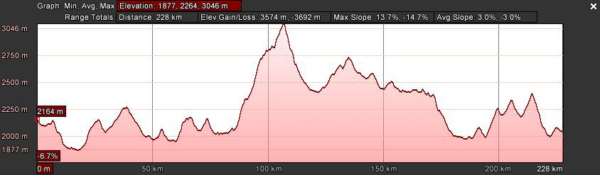
| [Graphs are built with incomplete data and are only general representations
of the topography.] |
|||
 |
  These
first few photos are from a tour in 1996. At that time the road from Dessie to
Mekele was gravel. Near Mekele the first stretch of paved road continued
for about 150km to the border. Agricultural practices, like harvesting tef by
hand, have changed little in the last two-decades. And if the geography has
changed it is imperceptible. The staggering change has been in the population
and the size and character of cities and towns. These
first few photos are from a tour in 1996. At that time the road from Dessie to
Mekele was gravel. Near Mekele the first stretch of paved road continued
for about 150km to the border. Agricultural practices, like harvesting tef by
hand, have changed little in the last two-decades. And if the geography has
changed it is imperceptible. The staggering change has been in the population
and the size and character of cities and towns. |
 |
|
 |
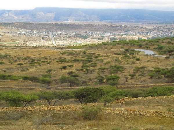
The plateau above Mekele has a large installation of wind powered turbines. It is a testimonial to how windy the area is, at least the plateau. It doesn't seem to be as windy down in the valley where most of the town is located. | ||
 |
From a moderate town, in two-decades,
Mekele has grown from a two-street town to a city that fills the valley. It has
to be a more than twenty fold increase in land area. There is a lot more
multi-story housing so the population has probably grown at least by that much.
It is not all bleak. The urban core has improved streets, curbs and sidewalks
and there is a bit of public art in some of the traffic circles and squares.
There are very few public green spaces like parks and they still have trouble
keeping the electricity and water on for twenty-four hours straight. |
 |
|
 |
  Commercial
activity seems to be booming: There is a large active central market and the
streets around it are lined with retail shops. Cell phone stores probably out
number all other. The others tend to be in clusters. There will be several men's
clothing stores, or women's clothing stores, or shoe shops, or traditional dress
shops and adjacent to each other or around the corner from another. Commercial
activity seems to be booming: There is a large active central market and the
streets around it are lined with retail shops. Cell phone stores probably out
number all other. The others tend to be in clusters. There will be several men's
clothing stores, or women's clothing stores, or shoe shops, or traditional dress
shops and adjacent to each other or around the corner from another. |
 |
|
 |
One interesting cluster was a street
with at least a half dozen shingles hanging for "Attorney and Counselor of Law".
Across the street was a string of bars and the neighborhood was filled with
restaurants, pool halls, juice houses, beauty shops and coffee shops.
One of the coffee shops was more of a garden with several large thatch roof
gazebos and half-walls with books stacked on top. Instead of sitting in groups
chatting at table, almost everyone at this establishment was sitting separately,
reading or working on computers. |
 |
|
 |
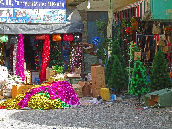 It
was only about two-weeks before Christmas that the merchants were unpacking and
putting out for display, their stock of Christmas decorations. Popular items are
plastic trees and colorful garlands. It
was only about two-weeks before Christmas that the merchants were unpacking and
putting out for display, their stock of Christmas decorations. Popular items are
plastic trees and colorful garlands.Part of the landscape of most major towns
is a memorial to the people who died in the struggle the over-throw the Derg and
the "rein of terror". When asked several people in town didn't know what the
monument was for. |
 |
|
 |
Out of Mekele (eleve 2100m) the road climbs steeply before becoming more moderate in grade. There is a ridge before a long gradual descent into May Mekden (elev 2020m). The total distance is 21km. There is another ridge and descent in the 16km to Agula (elev 2030m). The next 11km are more rolling, with an imperceptible net loss of elevation to Wukro (elev 2000m). The countryside is fairly arid and generally sparsely populated. | ||
|
Wukro stretches for several kilometers along the road and is lengthening.
Throughout the town there is new multi-story construction underway. Main street
features a constant dance of pedestrians, bicycles, tuk-tuks, donkey carts,
cars, SUVs, mini-buses, big intercity buses, goods trucks and heavy construction
vehicles weaving in and out of one another -- by-in-large cooperatively and
safely. The is little of noteworthy architecture in town, all though new
buildings tend to have more glass and transparency. The nicest building is the
Orthodox Church. |
 |
||
|
In the 7th century, early Muslims from
Mecca also sought refuge from
Quraysh persecution by travelling
to the Axumite
kingdom, a journey known in Islamic history as the First Hijra.
They were allowed to settle peacefully, perhaps near Axum, but one story puts
them in Nagash,
between Wukro
and Frewayne. In any case legend has it that for this the Prophet Mohamed is
said to have admonished his followers, “Leave the Abyssinians alone, so long as
they do not take the offensive.” |
|||
 |
  Churches
are the highlight between Wukro (elev 2000m) and Frewayne (elev 2480m) as well.
There are a couple of very visible churches perch on the tops of hills -- to be closer to God. The cynic would wonder whether it impacts church
attendance and participations Churches
are the highlight between Wukro (elev 2000m) and Frewayne (elev 2480m) as well.
There are a couple of very visible churches perch on the tops of hills -- to be closer to God. The cynic would wonder whether it impacts church
attendance and participations |
 |
|
 |
Turning west at Freweyne goes to Hawzen, the heart of rock hewed churches of
Gheralta district. There are over 100 rock hewed churches in Tigray Province and
34 of them are in Gheralta. Most of the countryside is cultivated. It is just past harvest time so a lot of the activity processing harvest; knocking the grain off the stock and separating it from the chaff (left). The typical traditional house in the area is a low-lying stone buildings with flat earthen roofs (right). The owner of a hotel in Hawzen had had a carrier in Colorado. A
few years ago he decided to return to his home village to retire. When he
left it had a population of about 1000. Today, he says the population is
15,000 -- I would guess that it is at least that. |
 |
|
 |
  Three
of the most accessible and notable churches in Gheralta District are at the tops of steep
sided Gheralta Mountains near Magab. The three sites are in two clusters. To
visit the three churches it is necessary to climb from about 2050m to 2300m, then descend to
1950m and climb back to 2150m and descend again. Three
of the most accessible and notable churches in Gheralta District are at the tops of steep
sided Gheralta Mountains near Magab. The three sites are in two clusters. To
visit the three churches it is necessary to climb from about 2050m to 2300m, then descend to
1950m and climb back to 2150m and descend again. |
 |
|
 |
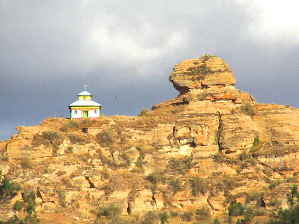
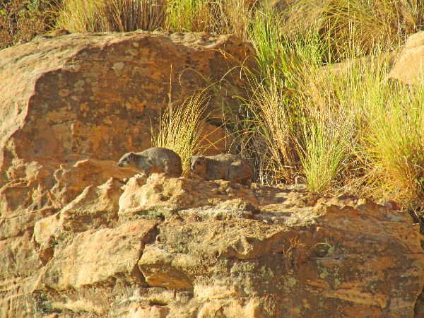  The
walk is as engaging as the churches. Besides the rugged countryside and
spectacular scenery, a family of rock hyrax (left) were warming themselves in
the morning sun. The
walk is as engaging as the churches. Besides the rugged countryside and
spectacular scenery, a family of rock hyrax (left) were warming themselves in
the morning sun.A sphinx-like rock formation is perched on top of Gheralta
mountain. |
 |
|
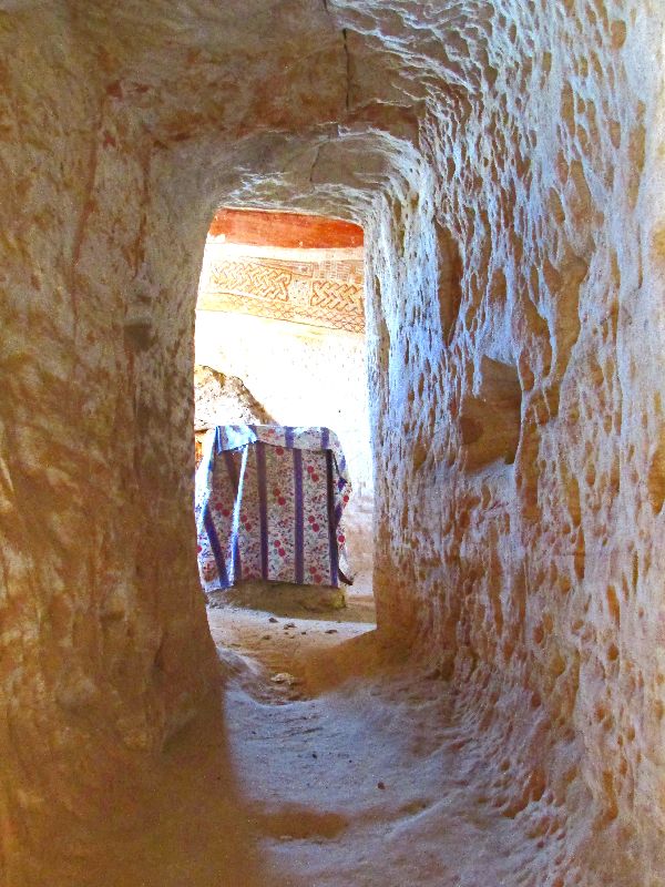
 Mariam Korkor. A hint of American mission-style achitecture |
   Excavated
into one of the haystack rocks on the top of Gheralta is Mariam Korkor, a church
dedicated to the Virgin Mary. The fascade seems to be built out and has the look
of mission-style architecture seen in the southwest United State. The church is a typical three-aisled basilica
shape with twelve pillars, seven decorated arches, vaults and dome. The pray
room is about 8 meters by 8 meters. Tradition
claims that this extraordinary monument was carved by God himself. Though this
and the other churches in the area are said to date from the 4th century, when
Christianity was introduced to Axum but the beautiful
paintings have a Byzantine influence which may date from the 13th or 14th century. Excavated
into one of the haystack rocks on the top of Gheralta is Mariam Korkor, a church
dedicated to the Virgin Mary. The fascade seems to be built out and has the look
of mission-style architecture seen in the southwest United State. The church is a typical three-aisled basilica
shape with twelve pillars, seven decorated arches, vaults and dome. The pray
room is about 8 meters by 8 meters. Tradition
claims that this extraordinary monument was carved by God himself. Though this
and the other churches in the area are said to date from the 4th century, when
Christianity was introduced to Axum but the beautiful
paintings have a Byzantine influence which may date from the 13th or 14th century. |
 |
|
 |
On the backside of the rock stack, accessible only by a vertigo producing ledge
is
Daniel Korkor Church. Unlike many chrches Daniel Korkor has only two rooms; the
prayer hall and a room for the holy-of-holies. The pray room is a very compact 5
meters by 5 meters. Unlike any other church I have visited, the priest pulled back the curtain shielding the holy-of-holies allowed it to be photographed, but only priests are allowed to approach it. The draped box should contain a replica of the Ark of the Covenant (a box 2 1/4 feet in height and width and 3 3/4 feet in length. containing the two stone tablets of the Ten Commandments.) The themes of the art is similar to those in other churches (below); |
 |
|


 |
 |
||
 On
the plateau of the Korkor churches are African olive trees and prickly pear
cactus. On
the plateau of the Korkor churches are African olive trees and prickly pear
cactus.The olive grows better in forests but it can tolerate droughts and
poor soils. The fruit is small with not to much flesh, it turns purple black
when mature and it doesn’t produce oil but serves as food not only for people
but also for animals like baboons, monkeys and birds. There are several dozen varieties of prickly pear cactus, all native to the Americas. The cactus is being promoted in Ethiopia from its drought resistant qualities and as a bridge food in famine conditions. Besides the fruit, the leaves can be cooked and eaten. |
|||


 |
 |
||
|
To get from the first set of churches to the third church you need to descend
350m in elevation to the village of Guh, and then hike and scale back up another
200m. This is one of the most inaccessible places of worship on the planet.
About three quarters of the way up there are six meters of sheer rock face that
must be negotiated -- barefoot. There are minimal toe holds and finger holds,
but these provide comfort to only the most agile. For those who are not
experience rock climbers, there is now a crew of local men at the ready to aid
the tourist. For five dollars, they will harness you up for a belay and expertly
guide your hands and feet to the right chink in the wall to safely get you up
and later back down the face. |
|||
 |
It is said that in 5th century AD
Egyptian priest Father Yemata walked to Ethiopia, climbed the mountains and
quarried the church out of the rock. A second version has the work being
done by nine monks, some of whom were fleeing persecution for their worship
while others joined them to get away from the secular life. Near the entrance
to Abuna Yemata Guh Church are some burial caves. There is no indication who the
bones belong to. The suggestion is that they are those of monks and locals who
wanted the location as there final resting place. |
||
 |
The final twenty meters to the entrance of the church is along a 1 meter wide
ledge. It would normally be sufficiently wide, except for the hundreds of feet
of sheer drop off to your left, so the mind render three-quarters of the width
unusable. Even staring directly at the wall to the right it take nerves of steel
and baby steps to get tot he entrance. To added to the disorientation, the wind
can whip around here, which neither helps with balance or reduces the vertigo.
The churches are built on mountain tops to be closer to heaven. This chamber
also had the heavenly quality of calmness (being out of the wind) and splendor
(most surfaces, including the ceiling (right) are painted). |
 |
|
 |
We were told that the paintings were the work of Father Yemata. As with many
sanctuaries, a painting of Miriam is very prominent. The other prominent figure
is that of Father Yemata riding a horse. It is interesting that the legend has
Father Yemata walking from Egypt, but he is memorialized on horseback. The artistic style, and images of the Axun cross, Gondar cross, and Lalibela cross (below), which wouldn't have existed in the time of Father Yemata, bring into question who the artist(s) were. |
 |
|


 |
|||
 |
 Returning
to the main road, the road climbs a net 230m over 17km, between Frewayne and Idaga Hamus.
The elevations of the towns are about 2480m and 2710m, respectively, but they
still sit lower than the mountains around them. Returning
to the main road, the road climbs a net 230m over 17km, between Frewayne and Idaga Hamus.
The elevations of the towns are about 2480m and 2710m, respectively, but they
still sit lower than the mountains around them.In one of the village, they
were quarrying stone blocks at the roadside in the middle of the village
(right). |
 |
|
 |
North of Idaga Hamus, a
large funeral procession occupied the road. The procession was lead by a color
guard, which was followed by about 20 men carrying automatic rifles, and then a
contingent that was more religious, including some priests. Behind these were
vehicles with the casket and musicians, and then hundreds of mourner in white,
walking, filled the highway. Cars, trucks and buses than came upon the
procession made no attempt to pass it. They bided their time until the
procession exited the highway at the road to the church after a couple of
kilometers. I would guess that the deceased was an older man of importance, who
had severed in the military. |
 |
|
 |
Though Adigrat has grown from a town to a city in the last twenty years, and the core has been cleared to make way for six lanes of road through the center, off to the side they have preserved some neighborhoods. They seem to be economically viable with coffee shops, restaurants, hotels and other small business. |
 |
|


 |
|||
 |
 Adigrat
(elev 2450m) lies in a valley between two mountain ranges. If you cross
the mountains to the east you will eventually descend into the Danakil
Depression or Afar Depression, one of the hottest (with daytime temperatures
surpassing 50 °C (122 °F)) and lowest points (-125m) on earth. It is not an
inviting destination for bicycling. Adigrat
(elev 2450m) lies in a valley between two mountain ranges. If you cross
the mountains to the east you will eventually descend into the Danakil
Depression or Afar Depression, one of the hottest (with daytime temperatures
surpassing 50 °C (122 °F)) and lowest points (-125m) on earth. It is not an
inviting destination for bicycling.
To the west is a 3050m ridge that separates it from western Tigray.
Three-quarters of the way up the hill, in the shadow of the cliffs is an
Orthodox Church. |
||
 |
Twenty years ago the only thing at the summit was a man with a
wheelbarrow full of prickly-pear catcus fruit, selling them for about a nickle a
piece. Today the village of Kisadaleka fills the saddle. The first town to
the west is Bizet (elev. 2020). From the summit to Bizet is 22km and 1000m of pretty
consistent descent. With the topography comes some big scenery and dramatic road engineering, but when compared to the Nile gorge and Tekeze Valley it is all rather tame. |
 |
|
 |


 |
 |
|
 Like
most cafes and many restaurants and hotels, the most popular one in Bizet was
run by women. It is a pleasant refuge, shaded by trees and set back from the
road. The "fancy" hotel is the Debre Damo, but this is the best place to eat. Like
most cafes and many restaurants and hotels, the most popular one in Bizet was
run by women. It is a pleasant refuge, shaded by trees and set back from the
road. The "fancy" hotel is the Debre Damo, but this is the best place to eat.
On the outskirts of Bizet is a memorial to a fighter in the ELF. |
 |
||
 |


 |
 |
|
 |
Between Bizet and Enticho are a couple more ridges, switchbacks, more children
chasing the bicycle demanding pens and money for miles and earth that comes in
red, gold, purple and other unique shades. The switchbacks make the grades
easier, the children eventually leave and what is most memorable is the
spectacular views. At midday, it was fascinating to watch lines of
parishioners (left) streaming away from a church in all directions. I was told
it was a holy day preceding Christmas so attendance was particularly strong. |
 |
|
 |
 In
Enticho, the desire for a cup of cinnamon tea placed me in the midst of a group
of people, some of whom spoke English. One of them, "Fish", said he had worked
for Kodak in Rochester, NY, for more than a decade. Thirteen years ago he
came home on vacation and stayed. He confirmed that he just decided not to go
back to work. In
Enticho, the desire for a cup of cinnamon tea placed me in the midst of a group
of people, some of whom spoke English. One of them, "Fish", said he had worked
for Kodak in Rochester, NY, for more than a decade. Thirteen years ago he
came home on vacation and stayed. He confirmed that he just decided not to go
back to work. |
 |
|
 |
  The
village of Gendebta (elev 2270m) has a spectacular setting on a ridge between
Enticho and Adwa. Other attributes beside the location are a school, clinic and
calm children,. The
village of Gendebta (elev 2270m) has a spectacular setting on a ridge between
Enticho and Adwa. Other attributes beside the location are a school, clinic and
calm children,. |
 |
|
 |
  At
every turn the scenery presents a new look -- each an equal of the others. At
every turn the scenery presents a new look -- each an equal of the others.
Much of the cattle in the area is Zebu (right). A hardy, droubt and disease
resistant breed that is found across sub-Sahelian Africa. |
||
 |
  This
is one of the areas that the Axum bicycle racing team uses for training. I hope
they appreciate how beautiful it is. This
is one of the areas that the Axum bicycle racing team uses for training. I hope
they appreciate how beautiful it is.
A close examination of the photos shows that the all have cycling shorts,
jersey and helmet, and most have click-in shoes and bicycle gloves, but they are
all riding bikes with 26" wheels and straight handbars. |
 |
|
 |
 Before
Ethiopia post-millennium economic boom Adwa and Adi Abun were two small towns
separated by several kilometers. The two have since grown together into a small
city and have an eight kilometer long retail corridor. Generally road,
electricity and water infrastructure have kept pace Before
Ethiopia post-millennium economic boom Adwa and Adi Abun were two small towns
separated by several kilometers. The two have since grown together into a small
city and have an eight kilometer long retail corridor. Generally road,
electricity and water infrastructure have kept pace |
 |
|
 |
Like many towns, Adi Abun has a memorial to fallen liberation soldiers of the
civil war (left). The long time industry of Adi Abun was a marble cutting factory. The new entry is an Almeda Textile PLC (Altex) factory (right). It produces T-shirts, polo shirts, trousers, bed sheets, canvas and other woven items. |
 |
|
|
(South: Addis Ababa to Mekele)
|
|||
 |
|||
|
|
Unique Programs To Special Places For Memories Of A Lifetime!
"Hosted by
DreamHost - earth friendly web hosting"
|
|
