
Tunisia
Odyssey: Eden to Oasis
Bicycle Africa / Ibike Tours
Dispatch 5 - Beni Khedache

Before 1998, from Ksar Hedada, you
had a choice of backtracking to Medenine on paved roads or taking a route
due north through the hills that shows as a
dirt track on the maps. Mostly we choose the direct route through the
wilderness. But its days as a rugged, isolated, traffic free, sometimes
gnarly and an intimate
mountain bike track are now history. Tunisia’s
 sprint
towards infrastructure development even came to the mountains.
Even without the new road, people have been living in these hills for a long time trying to eek
out a living. Although the land is generally barren, almost every drainage is crossed several times along its
course by a jessour (dike to hold the rain water), with a few old olive trees
and sometimes a fig tree and palm there to take advantage of whatever
moisture is trapped.
sprint
towards infrastructure development even came to the mountains.
Even without the new road, people have been living in these hills for a long time trying to eek
out a living. Although the land is generally barren, almost every drainage is crossed several times along its
course by a jessour (dike to hold the rain water), with a few old olive trees
and sometimes a fig tree and palm there to take advantage of whatever
moisture is trapped.
Back when the "year of investment" was moving around the region, along the way in the relevant district, there was evidence of new water mains being laid across the countryside, new rural electrification, fixing up the main streets of even the smallest trading centers along the highways with new asphalt, cement curbs, patterned brick sidewalks and often some kind of public art like a sculpture. (In Medenine the ten meter high sculpture represented a traditional woman’s cloth and jewelry. In Ksar Hadada the sculpture is stylized elements of a ksar.) If there was a construction crew on the road they said, "the road would be paved within the year", which was generally the case.
In one case before 2000, this transition won’t be soon enough for one of our bicyclists, who, with some irony, the rider turned to look at a first aid kit that had fallen from his pack. He fishtailed and went for a slide. After getting washed-up, slathered in antibiotics and wrapped in gauze, he finished the days ride. But the wound warranted a closer look so we took a side trips into Medenine to learn about the health care delivery system. The Tunisian physicians assistant at the hospital who scrubbed him up had been in Saudi Arabia during the Gulf War and was more than happy to have a opportunity to practice his English.
 Even with the recent developments it
is still a great ride.
The road, though in a mountainous area, only has a couple of longer climbs. It
is designed to accommodate tourist bus so it
picks its way carefully, winding through the mountains and over the mesas. Along the ways
you
can see the occasional additional ksours on a distant hill tops
or mesa.
Even with the recent developments it
is still a great ride.
The road, though in a mountainous area, only has a couple of longer climbs. It
is designed to accommodate tourist bus so it
picks its way carefully, winding through the mountains and over the mesas. Along the ways
you
can see the occasional additional ksours on a distant hill tops
or mesa.
 One
of the more striking phenomena in the generally multiple shades of beige
and olive drab landscape is the local women’s preference for dress of
red cloth. Throughout the area, near and far, amongst the mottled hills
were women walking or tending livestock in their bold, bright red dress.
One
of the more striking phenomena in the generally multiple shades of beige
and olive drab landscape is the local women’s preference for dress of
red cloth. Throughout the area, near and far, amongst the mottled hills
were women walking or tending livestock in their bold, bright red dress.
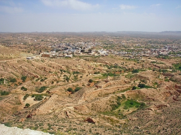
What was the old track and is now the new highway, ends in Beni Khedache. It is always with some surprise that we couldn’t find a restaurant there. But if you continued a couple of kilometers up a long grade to the ridge there is a tourist restaurant overlooking town. Beni Khedache is not a small town and has an active market so even after asking around, it is a bit of a mystery that we can't find any kind of restaurant. The usual conclusion is that everyone eats at home so there must not be a market for prepared food among the locals. The ridge top restaurant has a magnificent vista. We cooled our heels for a while with a long lunch since our destination was just a couple kilometers away -- and mostly downhill.
 In the
next valley,
there is cozy, semi-traditional, troglodyte-type dwelling reconfigured as tourist accommodations to be found in Zammour.
(The area is named after the dominant local family name, but it also
means "olive" in the Berber language,) The rooms at the inn are
caves carved into the hillside that very effectively shutout the
outside world -- very womb-like. Unless you are cloister phobic they are very calm and
tranquil. The accommodations come with western-style toilets and hot
water showers, but they are shared and separate modern block building
out in the yard.
In the
next valley,
there is cozy, semi-traditional, troglodyte-type dwelling reconfigured as tourist accommodations to be found in Zammour.
(The area is named after the dominant local family name, but it also
means "olive" in the Berber language,) The rooms at the inn are
caves carved into the hillside that very effectively shutout the
outside world -- very womb-like. Unless you are cloister phobic they are very calm and
tranquil. The accommodations come with western-style toilets and hot
water showers, but they are shared and separate modern block building
out in the yard.
The next valley is the Hallouf valley, It has some historical
significance because this is the route that Gen. Montgomery and the British
8th Army used in WWII to flank the Axis defensive positions, known as the
Mareth Line, in early 1943. The Mareth Line had stalled the Allies'
advance for four months. It is a complex, which stretched from the
coast into the nearby mountains, consisted of anti-tank mine, anti-personnel
mine fields, barb wire lines, bunkers, a nti-aircraft,
artillery, tanks, stretching from the sea to the mountains. Rommel's bunker.
Now-a-days it is much more tranquil and must have more water
in it than meets the eye. Tuck behind jassours on the valley floor were
some nice lush gardens of
leafy vegetables - clearly irrigated.
nti-aircraft,
artillery, tanks, stretching from the sea to the mountains. Rommel's bunker.
Now-a-days it is much more tranquil and must have more water
in it than meets the eye. Tuck behind jassours on the valley floor were
some nice lush gardens of
leafy vegetables - clearly irrigated.
 An
lodging option here is Ksar Hallouf. [Ed. note:
As of 2007 it is closed for an indeterminate period of time for renovation.]
An
lodging option here is Ksar Hallouf. [Ed. note:
As of 2007 it is closed for an indeterminate period of time for renovation.]
 Typical of most
ksours, this one is perched on the hill above the village.
The
accommodations are basic but sufficient, if you can get by with a cold
shower, a
couple of good meals and a simple bed of a mattress, with linens and a
blanket, on mats on the floor -- bring your own pillow and towel if you are
picayune.
Typical of most
ksours, this one is perched on the hill above the village.
The
accommodations are basic but sufficient, if you can get by with a cold
shower, a
couple of good meals and a simple bed of a mattress, with linens and a
blanket, on mats on the floor -- bring your own pillow and towel if you are
picayune.

 The road from Zammour to Ksar
Hallouf, while not
yet paved, at last passing, had been improved enough to drive most cars on. It used to be
restricted to mountain bikes and donkeys. Of course there is
always a chance that it has since reverted to that.
The road from Zammour to Ksar
Hallouf, while not
yet paved, at last passing, had been improved enough to drive most cars on. It used to be
restricted to mountain bikes and donkeys. Of course there is
always a chance that it has since reverted to that.
Here is the finished ribbon of
 asphalt winding through the hills between Ksar Hedada and Beni Khadache. What was once the preserve of donkey
travel and mountain bikers is now accessible to the biggest tourist buses--
road-bike cyclists.
asphalt winding through the hills between Ksar Hedada and Beni Khadache. What was once the preserve of donkey
travel and mountain bikers is now accessible to the biggest tourist buses--
road-bike cyclists.
![]()
![]()

![]()
Unique Programs To Special Places For Memories Of A Lifetime!
![]()
![]() Please
write if you have questions, suggestions and comments about our program or want to be
added to Bicycle Africa's mailing list. (Also let us know how you found this site.)
Please
write if you have questions, suggestions and comments about our program or want to be
added to Bicycle Africa's mailing list. (Also let us know how you found this site.)