| |
 The focus of the day was to explore the Bandiagara
escarpment. This is the section of Dogon Country that is most written
up in the guidebooks. A couple centuries ago the Dogon took refuge in
the cliffs to protect themselves from attacks by other ethnic groups.
It is suppose to be the "heart" of Dogon Country, though I
am not sure that where we had spent the last couple of days wasn't
more the heart. The area along the escarpment seemed to be so
tourist-savvy and culturally corrupted that it has lost its heart. The focus of the day was to explore the Bandiagara
escarpment. This is the section of Dogon Country that is most written
up in the guidebooks. A couple centuries ago the Dogon took refuge in
the cliffs to protect themselves from attacks by other ethnic groups.
It is suppose to be the "heart" of Dogon Country, though I
am not sure that where we had spent the last couple of days wasn't
more the heart. The area along the escarpment seemed to be so
tourist-savvy and culturally corrupted that it has lost its heart.
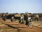
  Outside of Bandiagara, our handlers (a.k.a. guide) made sure we
paid additional 1000 CFA per person fees when we passed through
Djiguibombo, Koni Kombole, Telli and Ende. It didn't matter whether we
actually went into the village itself; passing by was sufficient to
trigger the fee. In most instances the fees we given to guide and we
never Outside of Bandiagara, our handlers (a.k.a. guide) made sure we
paid additional 1000 CFA per person fees when we passed through
Djiguibombo, Koni Kombole, Telli and Ende. It didn't matter whether we
actually went into the village itself; passing by was sufficient to
trigger the fee. In most instances the fees we given to guide and we
never
 were able to determine whether the village actually received the
money. [According to the tourism official we met later, they money
probably never got to the "village" because these fees
aren't legitimate.] Talk about feeling like a mobile ATM machine. were able to determine whether the village actually received the
money. [According to the tourism official we met later, they money
probably never got to the "village" because these fees
aren't legitimate.] Talk about feeling like a mobile ATM machine.
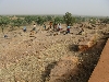
  A
lot of this section of Dogon country seems to be bed-rock.
Anyplace that has the slightest amount of soil associated with it is
planted in millet. Fulani cattle graze on the stubble of the harvested
fields. If the soil is deep enough to till, there might be peanuts and
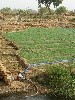
wind-rows of hibiscus. The most intense agriculture is around
the largest water holes, where the dominate crop is onions. It
is noteworthy that in the second half of the first decade of the
century, development projects started providing power pumps to help
with the irrigation. Gone are the scenes of the farmer walking
to the water hole to fill two calabash and then walking through the
garden broadcasting water until the calabash are empty and which point
he need to walk back to the water source. And so it went.
With the increase efficiency more land in under onion cultivation. I
am not sure that there is food security in onions but the must be good
money to be made. A
lot of this section of Dogon country seems to be bed-rock.
Anyplace that has the slightest amount of soil associated with it is
planted in millet. Fulani cattle graze on the stubble of the harvested
fields. If the soil is deep enough to till, there might be peanuts and
wind-rows of hibiscus. The most intense agriculture is around
the largest water holes, where the dominate crop is onions. It
is noteworthy that in the second half of the first decade of the
century, development projects started providing power pumps to help
with the irrigation. Gone are the scenes of the farmer walking
to the water hole to fill two calabash and then walking through the
garden broadcasting water until the calabash are empty and which point
he need to walk back to the water source. And so it went.
With the increase efficiency more land in under onion cultivation. I
am not sure that there is food security in onions but the must be good
money to be made.
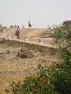
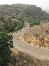
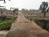
The ride along and over the escarpment provides some of the most
beautiful vistas and scenes of the tour so far: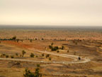 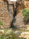 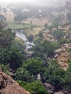 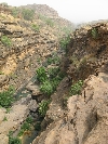 
After we parked the bikes we walk in the "heart" of Dogon
country, pausing multiple times to take in the extraordinary views.
The villages on the face of the cliffs are all abandon now, but they
are still a remarkable sight. And from the old villages you can look
down onto the new villages which is it own unique perspective. Among
these locations mosques, meeting places, traditional religion relics
and sacred sites. In all of the village above and below the cliff are
the signature, square, clay granaries, with the thatched peaked roofs
of the Dogon people. Depending upon what material was in most
abundance, houses, kitchens and storage buildings were constructed of
stone or clay. Regardless, all of the villages had a compactness,
coziness and human scale to them that creates a very nice and
picturesque aesthetic. 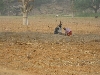 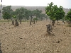 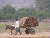  |
Addendum:
If they could vote President Obama
could
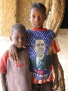
take Dogon Country.
Nice map of the escarpment but
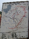
farsightedly inaccurate.
|


